You are here: Home > Network List > TA - USArray Transportable Network (new EarthScope stations) Stations List
> Station N27A Anderson Farm, Haxtun, CO, USA > Earthquake Result Viewer
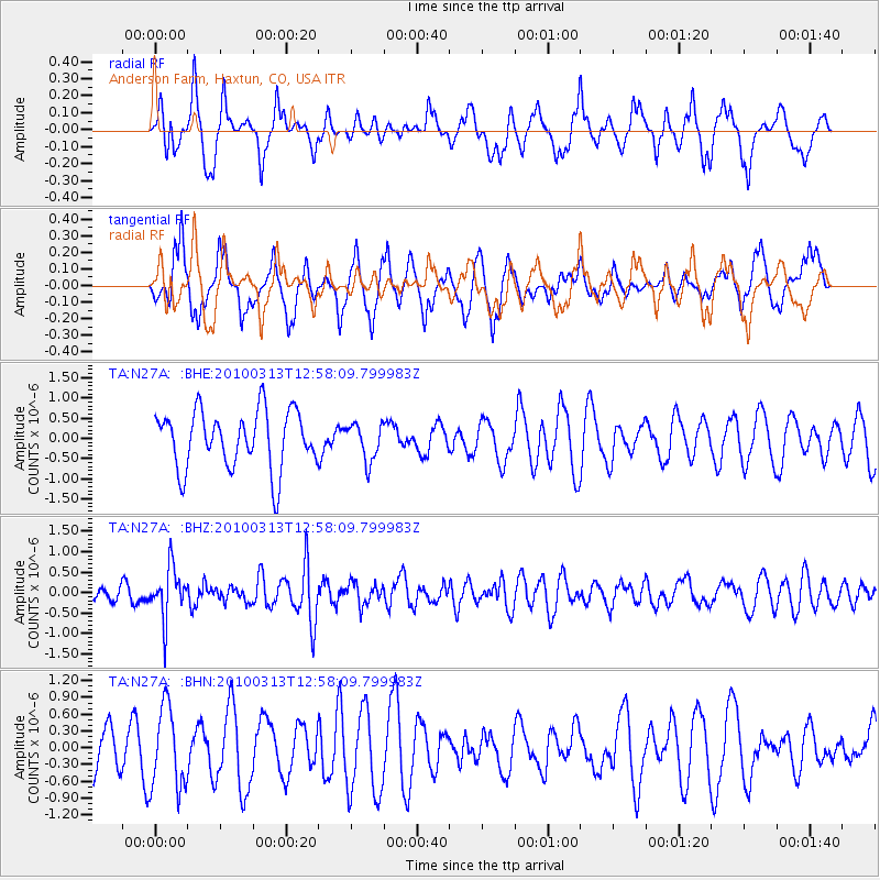
N27A Anderson Farm, Haxtun, CO, USA - Earthquake Result Viewer
*The percent match for this event was below the threshold and hence no stack was calculated.
| Earthquake location: |
Near East Coast Of Honshu, Japan |
| Earthquake latitude/longitude: |
37.6/141.3 |
| Earthquake time(UTC): |
2010/03/13 (072) 12:46:26 GMT |
| Earthquake Depth: |
77 km |
| Earthquake Magnitude: |
5.7 MB, 5.6 MW, 5.5 MW |
| Earthquake Catalog/Contributor: |
WHDF/NEIC |
|
| Network: |
TA USArray Transportable Network (new EarthScope stations) |
| Station: |
N27A Anderson Farm, Haxtun, CO, USA |
| Lat/Lon: |
40.81 N/102.54 W |
| Elevation: |
1228 m |
|
| Distance: |
82.6 deg |
| Az: |
43.401 deg |
| Baz: |
314.028 deg |
| Ray Param: |
$rayparam |
*The percent match for this event was below the threshold and hence was not used in the summary stack. |
|
| Radial Match: |
42.855087 % |
| Radial Bump: |
319 |
| Transverse Match: |
43.11929 % |
| Transverse Bump: |
352 |
| SOD ConfigId: |
308276 |
| Insert Time: |
2010-06-22 19:01:34.056 +0000 |
| GWidth: |
2.5 |
| Max Bumps: |
400 |
| Tol: |
0.001 |
|
Signal To Noise
| Channel | StoN | STA | LTA |
| TA:N27A: :BHZ:20100313T12:58:09.799983Z | 2.2083054 | 6.228655E-7 | 2.8205588E-7 |
| TA:N27A: :BHN:20100313T12:58:09.799983Z | 1.0720121 | 7.270309E-7 | 6.7819286E-7 |
| TA:N27A: :BHE:20100313T12:58:09.799983Z | 0.6410971 | 4.5583886E-7 | 7.110293E-7 |
| Arrivals |
| Ps | |
| PpPs | |
| PsPs/PpSs | |


