You are here: Home > Network List > UU - University of Utah Regional Network Stations List
> Station FOR1 Milford Southwest, UT, USA > Earthquake Result Viewer
FOR1 Milford Southwest, UT, USA - Earthquake Result Viewer
| Earthquake location: |
Near West Coast Of Honshu, Japan |
| Earthquake latitude/longitude: |
37.5/137.3 |
| Earthquake time(UTC): |
2023/05/05 (125) 05:42:04 GMT |
| Earthquake Depth: |
8.7 km |
| Earthquake Magnitude: |
6.2 mww |
| Earthquake Catalog/Contributor: |
NEIC PDE/us |
|
| Network: |
UU University of Utah Regional Network |
| Station: |
FOR1 Milford Southwest, UT, USA |
| Lat/Lon: |
38.37 N/113.09 W |
| Elevation: |
1642 m |
|
| Distance: |
80.5 deg |
| Az: |
48.664 deg |
| Baz: |
310.597 deg |
| Ray Param: |
0.04825414 |
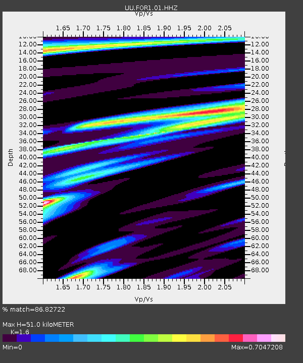
| Estimated Moho Depth: |
51.0 km |
| Estimated Crust Vp/Vs: |
1.60 |
| Assumed Crust Vp: |
6.276 km/s |
| Estimated Crust Vs: |
3.922 km/s |
| Estimated Crust Poisson's Ratio: |
0.18 |
|
| Radial Match: |
86.82722 % |
| Radial Bump: |
328 |
| Transverse Match: |
83.1306 % |
| Transverse Bump: |
330 |
| SOD ConfigId: |
30536071 |
| Insert Time: |
2023-05-19 06:27:30.245 +0000 |
| GWidth: |
2.5 |
| Max Bumps: |
400 |
| Tol: |
0.001 |
|

Signal To Noise
| Channel | StoN | STA | LTA |
| UU:FOR1:01:HHZ:20230505T05:53:45.089973Z | 9.661509 | 1.9707682E-6 | 2.0398143E-7 |
| UU:FOR1:01:HHN:20230505T05:53:45.089973Z | 3.4425082 | 4.3906178E-7 | 1.2754124E-7 |
| UU:FOR1:01:HHE:20230505T05:53:45.089973Z | 7.5266714 | 6.6480084E-7 | 8.832601E-8 |
| Arrivals |
| Ps | 5.0 SECOND |
| PpPs | 21 SECOND |
| PsPs/PpSs | 26 SECOND |


