You are here: Home > Network List > IW - Intermountain West Stations List
> Station FLWY Flagg Ranch, Wyoming, USA > Earthquake Result Viewer
FLWY Flagg Ranch, Wyoming, USA - Earthquake Result Viewer
| Earthquake location: |
Ionian Sea |
| Earthquake latitude/longitude: |
37.5/20.6 |
| Earthquake time(UTC): |
2018/10/25 (298) 22:54:52 GMT |
| Earthquake Depth: |
14 km |
| Earthquake Magnitude: |
6.8 Mww |
| Earthquake Catalog/Contributor: |
NEIC PDE/us |
|
| Network: |
IW Intermountain West |
| Station: |
FLWY Flagg Ranch, Wyoming, USA |
| Lat/Lon: |
44.08 N/110.70 W |
| Elevation: |
2078 m |
|
| Distance: |
87.6 deg |
| Az: |
327.166 deg |
| Baz: |
36.745 deg |
| Ray Param: |
0.043227732 |
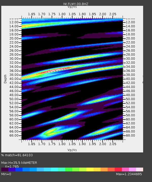
| Estimated Moho Depth: |
35.5 km |
| Estimated Crust Vp/Vs: |
1.76 |
| Assumed Crust Vp: |
6.35 km/s |
| Estimated Crust Vs: |
3.598 km/s |
| Estimated Crust Poisson's Ratio: |
0.26 |
|
| Radial Match: |
91.64103 % |
| Radial Bump: |
344 |
| Transverse Match: |
86.635475 % |
| Transverse Bump: |
382 |
| SOD ConfigId: |
3103472 |
| Insert Time: |
2018-11-09 16:50:55.890 +0000 |
| GWidth: |
2.5 |
| Max Bumps: |
400 |
| Tol: |
0.001 |
|

Signal To Noise
| Channel | StoN | STA | LTA |
| IW:FLWY:00:BHZ:20181025T23:07:08.490024Z | 3.3620543 | 5.264613E-7 | 1.5658917E-7 |
| IW:FLWY:00:BH1:20181025T23:07:08.490024Z | 1.3989072 | 2.6757004E-7 | 1.9127077E-7 |
| IW:FLWY:00:BH2:20181025T23:07:08.490024Z | 1.3267711 | 2.753948E-7 | 2.0756765E-7 |
| Arrivals |
| Ps | 4.4 SECOND |
| PpPs | 15 SECOND |
| PsPs/PpSs | 19 SECOND |


