You are here: Home > Network List > UW - Pacific Northwest Regional Seismic Network Stations List
> Station ASR2 Mt. Adams - Stagman Ridge, WA, USA > Earthquake Result Viewer
ASR2 Mt. Adams - Stagman Ridge, WA, USA - Earthquake Result Viewer
| Earthquake location: |
Near West Coast Of Honshu, Japan |
| Earthquake latitude/longitude: |
37.5/137.3 |
| Earthquake time(UTC): |
2023/05/05 (125) 05:42:04 GMT |
| Earthquake Depth: |
8.7 km |
| Earthquake Magnitude: |
6.2 mww |
| Earthquake Catalog/Contributor: |
NEIC PDE/us |
|
| Network: |
UW Pacific Northwest Regional Seismic Network |
| Station: |
ASR2 Mt. Adams - Stagman Ridge, WA, USA |
| Lat/Lon: |
46.14 N/121.60 W |
| Elevation: |
1274 m |
|
| Distance: |
70.8 deg |
| Az: |
46.28 deg |
| Baz: |
304.287 deg |
| Ray Param: |
0.054789856 |
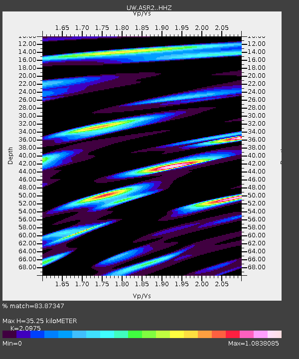
| Estimated Moho Depth: |
35.25 km |
| Estimated Crust Vp/Vs: |
2.10 |
| Assumed Crust Vp: |
6.597 km/s |
| Estimated Crust Vs: |
3.145 km/s |
| Estimated Crust Poisson's Ratio: |
0.35 |
|
| Radial Match: |
83.87347 % |
| Radial Bump: |
400 |
| Transverse Match: |
66.171715 % |
| Transverse Bump: |
400 |
| SOD ConfigId: |
30536071 |
| Insert Time: |
2023-05-19 06:28:07.699 +0000 |
| GWidth: |
2.5 |
| Max Bumps: |
400 |
| Tol: |
0.001 |
|

Signal To Noise
| Channel | StoN | STA | LTA |
| UW:ASR2: :HHZ:20230505T05:52:49.529976Z | 9.279617 | 2.5129193E-6 | 2.707999E-7 |
| UW:ASR2: :HHN:20230505T05:52:49.529976Z | 2.2889922 | 5.761734E-7 | 2.517149E-7 |
| UW:ASR2: :HHE:20230505T05:52:49.529976Z | 3.5130208 | 1.0378196E-6 | 2.9542088E-7 |
| Arrivals |
| Ps | 6.1 SECOND |
| PpPs | 16 SECOND |
| PsPs/PpSs | 22 SECOND |


