You are here: Home > Network List > UW - Pacific Northwest Regional Seismic Network Stations List
> Station CHIMA Chimacum High School, Chimacum, WA, USA > Earthquake Result Viewer
CHIMA Chimacum High School, Chimacum, WA, USA - Earthquake Result Viewer
| Earthquake location: |
Near West Coast Of Honshu, Japan |
| Earthquake latitude/longitude: |
37.5/137.3 |
| Earthquake time(UTC): |
2023/05/05 (125) 05:42:04 GMT |
| Earthquake Depth: |
8.7 km |
| Earthquake Magnitude: |
6.2 mww |
| Earthquake Catalog/Contributor: |
NEIC PDE/us |
|
| Network: |
UW Pacific Northwest Regional Seismic Network |
| Station: |
CHIMA Chimacum High School, Chimacum, WA, USA |
| Lat/Lon: |
48.01 N/122.78 W |
| Elevation: |
38 m |
|
| Distance: |
69.0 deg |
| Az: |
45.098 deg |
| Baz: |
303.017 deg |
| Ray Param: |
0.0559165 |
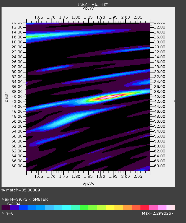
| Estimated Moho Depth: |
39.75 km |
| Estimated Crust Vp/Vs: |
1.94 |
| Assumed Crust Vp: |
6.566 km/s |
| Estimated Crust Vs: |
3.385 km/s |
| Estimated Crust Poisson's Ratio: |
0.32 |
|
| Radial Match: |
85.00089 % |
| Radial Bump: |
400 |
| Transverse Match: |
81.98151 % |
| Transverse Bump: |
400 |
| SOD ConfigId: |
30536071 |
| Insert Time: |
2023-05-19 06:28:31.465 +0000 |
| GWidth: |
2.5 |
| Max Bumps: |
400 |
| Tol: |
0.001 |
|

Signal To Noise
| Channel | StoN | STA | LTA |
| UW:CHIMA: :HHZ:20230505T05:52:39.029976Z | 8.967757 | 2.751435E-6 | 3.0681417E-7 |
| UW:CHIMA: :HHN:20230505T05:52:39.029976Z | 1.4230621 | 7.160693E-7 | 5.031891E-7 |
| UW:CHIMA: :HHE:20230505T05:52:39.029976Z | 2.2645848 | 1.2801122E-6 | 5.6527455E-7 |
| Arrivals |
| Ps | 5.9 SECOND |
| PpPs | 17 SECOND |
| PsPs/PpSs | 23 SECOND |


