You are here: Home > Network List > UW - Pacific Northwest Regional Seismic Network Stations List
> Station DOTY Weyerhaeuser Tree Farm, Grays Harbor County, WA, USA > Earthquake Result Viewer
DOTY Weyerhaeuser Tree Farm, Grays Harbor County, WA, USA - Earthquake Result Viewer
| Earthquake location: |
Near West Coast Of Honshu, Japan |
| Earthquake latitude/longitude: |
37.5/137.3 |
| Earthquake time(UTC): |
2023/05/05 (125) 05:42:04 GMT |
| Earthquake Depth: |
8.7 km |
| Earthquake Magnitude: |
6.2 mww |
| Earthquake Catalog/Contributor: |
NEIC PDE/us |
|
| Network: |
UW Pacific Northwest Regional Seismic Network |
| Station: |
DOTY Weyerhaeuser Tree Farm, Grays Harbor County, WA, USA |
| Lat/Lon: |
46.70 N/123.37 W |
| Elevation: |
430 m |
|
| Distance: |
69.4 deg |
| Az: |
46.503 deg |
| Baz: |
303.083 deg |
| Ray Param: |
0.05566625 |
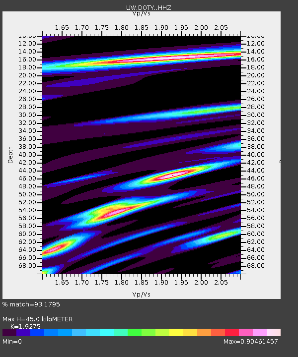
| Estimated Moho Depth: |
45.0 km |
| Estimated Crust Vp/Vs: |
1.93 |
| Assumed Crust Vp: |
6.566 km/s |
| Estimated Crust Vs: |
3.407 km/s |
| Estimated Crust Poisson's Ratio: |
0.32 |
|
| Radial Match: |
93.1795 % |
| Radial Bump: |
392 |
| Transverse Match: |
81.103935 % |
| Transverse Bump: |
382 |
| SOD ConfigId: |
30536071 |
| Insert Time: |
2023-05-19 06:28:57.319 +0000 |
| GWidth: |
2.5 |
| Max Bumps: |
400 |
| Tol: |
0.001 |
|

Signal To Noise
| Channel | StoN | STA | LTA |
| UW:DOTY: :HHZ:20230505T05:52:41.370002Z | 12.097043 | 2.6140594E-6 | 2.1609078E-7 |
| UW:DOTY: :HHN:20230505T05:52:41.370002Z | 1.35599 | 4.2826778E-7 | 3.15834E-7 |
| UW:DOTY: :HHE:20230505T05:52:41.370002Z | 3.7609503 | 1.0796176E-6 | 2.870598E-7 |
| Arrivals |
| Ps | 6.6 SECOND |
| PpPs | 19 SECOND |
| PsPs/PpSs | 26 SECOND |


