You are here: Home > Network List > UW - Pacific Northwest Regional Seismic Network Stations List
> Station MULN Lyman, WA, USA > Earthquake Result Viewer
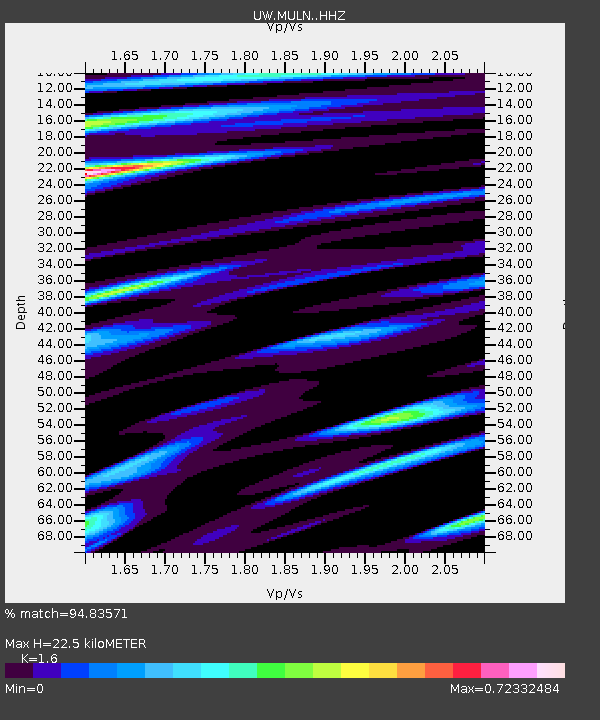
MULN Lyman, WA, USA - Earthquake Result Viewer
| Earthquake location: |
Near West Coast Of Honshu, Japan |
| Earthquake latitude/longitude: |
37.5/137.3 |
| Earthquake time(UTC): |
2023/05/05 (125) 05:42:04 GMT |
| Earthquake Depth: |
8.7 km |
| Earthquake Magnitude: |
6.2 mww |
| Earthquake Catalog/Contributor: |
NEIC PDE/us |
|
| Network: |
UW Pacific Northwest Regional Seismic Network |
| Station: |
MULN Lyman, WA, USA |
| Lat/Lon: |
48.54 N/122.06 W |
| Elevation: |
102 m |
|
| Distance: |
69.2 deg |
| Az: |
44.347 deg |
| Baz: |
303.282 deg |
| Ray Param: |
0.05583974 |
| Estimated Moho Depth: |
22.5 km |
| Estimated Crust Vp/Vs: |
1.60 |
| Assumed Crust Vp: |
6.566 km/s |
| Estimated Crust Vs: |
4.104 km/s |
| Estimated Crust Poisson's Ratio: |
0.18 |
|
| Radial Match: |
94.83571 % |
| Radial Bump: |
400 |
| Transverse Match: |
86.33264 % |
| Transverse Bump: |
400 |
| SOD ConfigId: |
30536071 |
| Insert Time: |
2023-05-19 06:30:22.453 +0000 |
| GWidth: |
2.5 |
| Max Bumps: |
400 |
| Tol: |
0.001 |
|

Signal To Noise
| Channel | StoN | STA | LTA |
| UW:MULN: :HHZ:20230505T05:52:39.739998Z | 28.855753 | 2.5562088E-6 | 8.858576E-8 |
| UW:MULN: :HHN:20230505T05:52:39.739998Z | 4.2842813 | 7.3126535E-7 | 1.7068565E-7 |
| UW:MULN: :HHE:20230505T05:52:39.739998Z | 4.98701 | 6.4113493E-7 | 1.28561E-7 |
| Arrivals |
| Ps | 2.1 SECOND |
| PpPs | 8.5 SECOND |
| PsPs/PpSs | 11 SECOND |


