You are here: Home > Network List > UW - Pacific Northwest Regional Seismic Network Stations List
> Station RER Emerald Ridge, Mount Rainier, WA, USA > Earthquake Result Viewer
RER Emerald Ridge, Mount Rainier, WA, USA - Earthquake Result Viewer
| Earthquake location: |
Near West Coast Of Honshu, Japan |
| Earthquake latitude/longitude: |
37.5/137.3 |
| Earthquake time(UTC): |
2023/05/05 (125) 05:42:04 GMT |
| Earthquake Depth: |
8.7 km |
| Earthquake Magnitude: |
6.2 mww |
| Earthquake Catalog/Contributor: |
NEIC PDE/us |
|
| Network: |
UW Pacific Northwest Regional Seismic Network |
| Station: |
RER Emerald Ridge, Mount Rainier, WA, USA |
| Lat/Lon: |
46.82 N/121.84 W |
| Elevation: |
1751 m |
|
| Distance: |
70.2 deg |
| Az: |
45.784 deg |
| Baz: |
303.944 deg |
| Ray Param: |
0.05514094 |
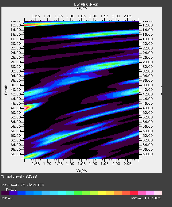
| Estimated Moho Depth: |
47.75 km |
| Estimated Crust Vp/Vs: |
1.60 |
| Assumed Crust Vp: |
6.597 km/s |
| Estimated Crust Vs: |
4.123 km/s |
| Estimated Crust Poisson's Ratio: |
0.18 |
|
| Radial Match: |
87.82538 % |
| Radial Bump: |
400 |
| Transverse Match: |
69.77084 % |
| Transverse Bump: |
400 |
| SOD ConfigId: |
30536071 |
| Insert Time: |
2023-05-19 06:30:59.252 +0000 |
| GWidth: |
2.5 |
| Max Bumps: |
400 |
| Tol: |
0.001 |
|

Signal To Noise
| Channel | StoN | STA | LTA |
| UW:RER: :HHZ:20230505T05:52:46.349983Z | 12.497225 | 2.1793442E-6 | 1.7438624E-7 |
| UW:RER: :HHN:20230505T05:52:46.349983Z | 1.9138591 | 6.001434E-7 | 3.1357763E-7 |
| UW:RER: :HHE:20230505T05:52:46.349983Z | 3.069851 | 8.690906E-7 | 2.8310515E-7 |
| Arrivals |
| Ps | 4.5 SECOND |
| PpPs | 18 SECOND |
| PsPs/PpSs | 23 SECOND |


