You are here: Home > Network List > TA - USArray Transportable Network (new EarthScope stations) Stations List
> Station A29A Manning Farm, Rocklake, ND, USA > Earthquake Result Viewer
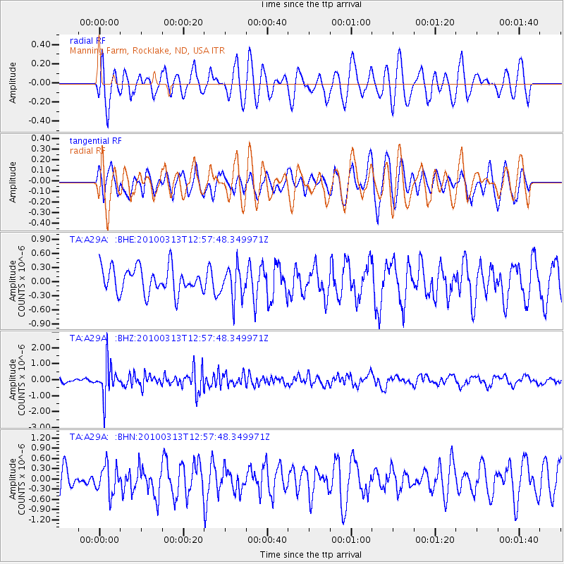
A29A Manning Farm, Rocklake, ND, USA - Earthquake Result Viewer
*The percent match for this event was below the threshold and hence no stack was calculated.
| Earthquake location: |
Near East Coast Of Honshu, Japan |
| Earthquake latitude/longitude: |
37.6/141.3 |
| Earthquake time(UTC): |
2010/03/13 (072) 12:46:26 GMT |
| Earthquake Depth: |
77 km |
| Earthquake Magnitude: |
5.7 MB, 5.6 MW, 5.5 MW |
| Earthquake Catalog/Contributor: |
WHDF/NEIC |
|
| Network: |
TA USArray Transportable Network (new EarthScope stations) |
| Station: |
A29A Manning Farm, Rocklake, ND, USA |
| Lat/Lon: |
48.92 N/99.23 W |
| Elevation: |
480 m |
|
| Distance: |
78.5 deg |
| Az: |
35.87 deg |
| Baz: |
315.118 deg |
| Ray Param: |
$rayparam |
*The percent match for this event was below the threshold and hence was not used in the summary stack. |
|
| Radial Match: |
61.091446 % |
| Radial Bump: |
400 |
| Transverse Match: |
61.47759 % |
| Transverse Bump: |
400 |
| SOD ConfigId: |
308276 |
| Insert Time: |
2010-06-22 19:09:27.829 +0000 |
| GWidth: |
2.5 |
| Max Bumps: |
400 |
| Tol: |
0.001 |
|
Signal To Noise
| Channel | StoN | STA | LTA |
| TA:A29A: :BHZ:20100313T12:57:48.349971Z | 5.362345 | 1.0595415E-6 | 1.975892E-7 |
| TA:A29A: :BHN:20100313T12:57:48.349971Z | 1.0176536 | 4.2832457E-7 | 4.2089428E-7 |
| TA:A29A: :BHE:20100313T12:57:48.349971Z | 1.2598919 | 3.365527E-7 | 2.6712823E-7 |
| Arrivals |
| Ps | |
| PpPs | |
| PsPs/PpSs | |


