You are here: Home > Network List > TX - Texas Seismological Network Stations List
> Station FW16 Waxahatchie > Earthquake Result Viewer
FW16 Waxahatchie - Earthquake Result Viewer
| Earthquake location: |
Ionian Sea |
| Earthquake latitude/longitude: |
37.5/20.6 |
| Earthquake time(UTC): |
2018/10/25 (298) 22:54:52 GMT |
| Earthquake Depth: |
14 km |
| Earthquake Magnitude: |
6.8 Mww |
| Earthquake Catalog/Contributor: |
NEIC PDE/us |
|
| Network: |
TX Texas Seismological Network |
| Station: |
FW16 Waxahatchie |
| Lat/Lon: |
32.48 N/96.90 W |
| Elevation: |
215 m |
|
| Distance: |
89.2 deg |
| Az: |
311.407 deg |
| Baz: |
44.882 deg |
| Ray Param: |
0.04202609 |
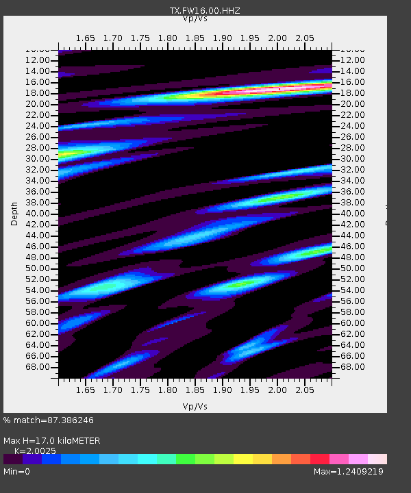
| Estimated Moho Depth: |
17.0 km |
| Estimated Crust Vp/Vs: |
2.00 |
| Assumed Crust Vp: |
6.38 km/s |
| Estimated Crust Vs: |
3.186 km/s |
| Estimated Crust Poisson's Ratio: |
0.33 |
|
| Radial Match: |
87.386246 % |
| Radial Bump: |
400 |
| Transverse Match: |
85.42992 % |
| Transverse Bump: |
400 |
| SOD ConfigId: |
3103472 |
| Insert Time: |
2018-11-09 16:52:48.322 +0000 |
| GWidth: |
2.5 |
| Max Bumps: |
400 |
| Tol: |
0.001 |
|

Signal To Noise
| Channel | StoN | STA | LTA |
| TX:FW16:00:HHZ:20181025T23:07:16.155002Z | 2.6491635 | 6.7619794E-7 | 2.552496E-7 |
| TX:FW16:00:HH1:20181025T23:07:16.155002Z | 1.882842 | 3.562711E-7 | 1.8921988E-7 |
| TX:FW16:00:HH2:20181025T23:07:16.155002Z | 0.8809044 | 2.6349898E-7 | 2.9912323E-7 |
| Arrivals |
| Ps | 2.7 SECOND |
| PpPs | 7.9 SECOND |
| PsPs/PpSs | 11 SECOND |


