You are here: Home > Network List > TA - USArray Transportable Network (new EarthScope stations) Stations List
> Station 635A Leesville, TX, USA > Earthquake Result Viewer
635A Leesville, TX, USA - Earthquake Result Viewer
*The percent match for this event was below the threshold and hence no stack was calculated.
| Earthquake location: |
Near East Coast Of Honshu, Japan |
| Earthquake latitude/longitude: |
37.6/141.3 |
| Earthquake time(UTC): |
2010/03/13 (072) 12:46:26 GMT |
| Earthquake Depth: |
77 km |
| Earthquake Magnitude: |
5.7 MB, 5.6 MW, 5.5 MW |
| Earthquake Catalog/Contributor: |
WHDF/NEIC |
|
| Network: |
TA USArray Transportable Network (new EarthScope stations) |
| Station: |
635A Leesville, TX, USA |
| Lat/Lon: |
29.39 N/97.77 W |
| Elevation: |
119 m |
|
| Distance: |
93.4 deg |
| Az: |
48.588 deg |
| Baz: |
316.952 deg |
| Ray Param: |
$rayparam |
*The percent match for this event was below the threshold and hence was not used in the summary stack. |
|
| Radial Match: |
43.981644 % |
| Radial Bump: |
400 |
| Transverse Match: |
64.781136 % |
| Transverse Bump: |
400 |
| SOD ConfigId: |
308276 |
| Insert Time: |
2010-06-22 19:13:18.003 +0000 |
| GWidth: |
2.5 |
| Max Bumps: |
400 |
| Tol: |
0.001 |
|
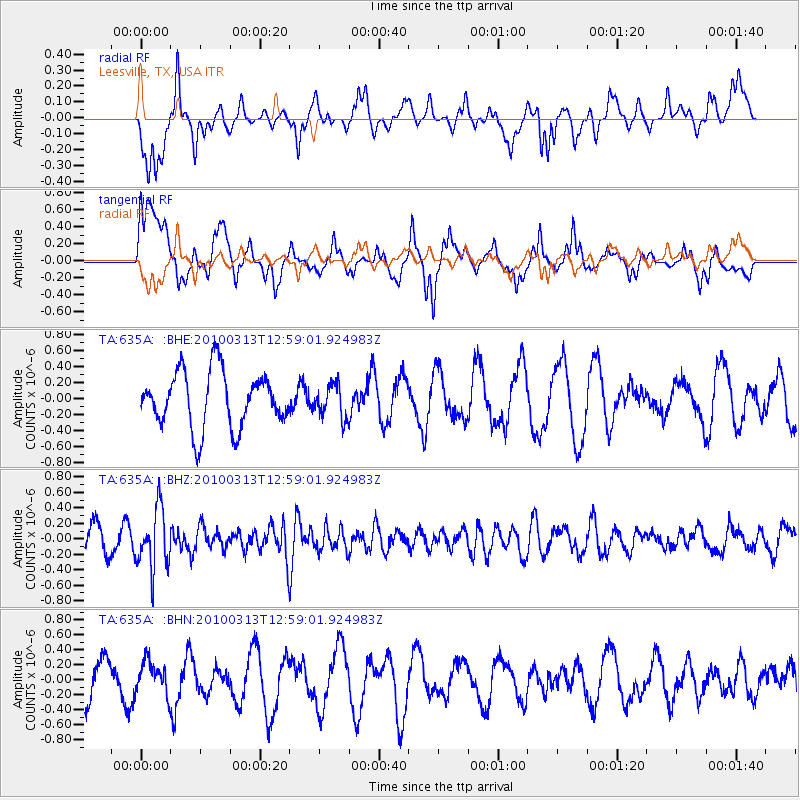
Signal To Noise
| Channel | StoN | STA | LTA |
| TA:635A: :BHZ:20100313T12:59:01.924983Z | 2.3828337 | 3.8649034E-7 | 1.6219778E-7 |
| TA:635A: :BHN:20100313T12:59:01.924983Z | 0.976274 | 2.174585E-7 | 2.2274332E-7 |
| TA:635A: :BHE:20100313T12:59:01.924983Z | 0.583221 | 2.0373076E-7 | 3.4931998E-7 |
| Arrivals |
| Ps | |
| PpPs | |
| PsPs/PpSs | |


