You are here: Home > Network List > US - United States National Seismic Network Stations List
> Station AMTX Amarillo, Texas, USA > Earthquake Result Viewer
AMTX Amarillo, Texas, USA - Earthquake Result Viewer
*The percent match for this event was below the threshold and hence no stack was calculated.
| Earthquake location: |
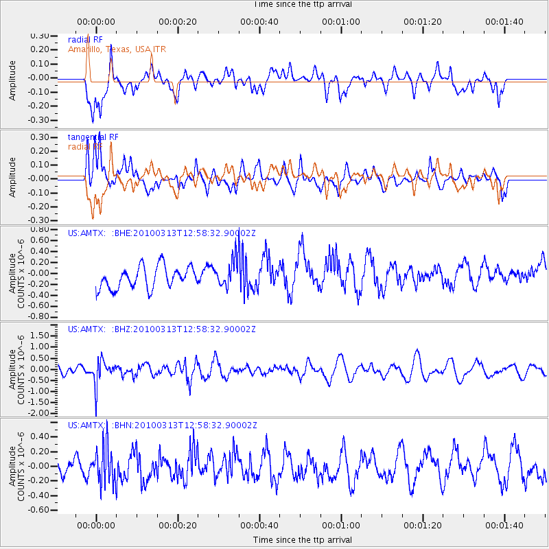
Near East Coast Of Honshu, Japan |
| Earthquake latitude/longitude: |
37.6/141.3 |
| Earthquake time(UTC): |
2010/03/13 (072) 12:46:26 GMT |
| Earthquake Depth: |
77 km |
| Earthquake Magnitude: |
5.7 MB, 5.6 MW, 5.5 MW |
| Earthquake Catalog/Contributor: |
WHDF/NEIC |
|
| Network: |
US United States National Seismic Network |
| Station: |
AMTX Amarillo, Texas, USA |
| Lat/Lon: |
34.53 N/101.41 W |
| Elevation: |
1010 m |
|
| Distance: |
87.6 deg |
| Az: |
47.252 deg |
| Baz: |
315.047 deg |
| Ray Param: |
$rayparam |
*The percent match for this event was below the threshold and hence was not used in the summary stack. |
|
| Radial Match: |
48.895336 % |
| Radial Bump: |
400 |
| Transverse Match: |
67.02146 % |
| Transverse Bump: |
400 |
| SOD ConfigId: |
308276 |
| Insert Time: |
2010-06-22 19:14:15.573 +0000 |
| GWidth: |
2.5 |
| Max Bumps: |
400 |
| Tol: |
0.001 |
|
Signal To Noise
| Channel | StoN | STA | LTA |
| US:AMTX: :BHZ:20100313T12:58:32.90002Z | 2.618764 | 5.725723E-7 | 2.1864219E-7 |
| US:AMTX: :BHN:20100313T12:58:32.90002Z | 1.0964316 | 2.532193E-7 | 2.3094856E-7 |
| US:AMTX: :BHE:20100313T12:58:32.90002Z | 1.8627921 | 3.5111574E-7 | 1.8848895E-7 |
| Arrivals |
| Ps | |
| PpPs | |
| PsPs/PpSs | |


