You are here: Home > Network List > US - United States National Seismic Network Stations List
> Station HDIL Hopedale, Illinois, USA > Earthquake Result Viewer
HDIL Hopedale, Illinois, USA - Earthquake Result Viewer
| Earthquake location: |
Ionian Sea |
| Earthquake latitude/longitude: |
37.5/20.6 |
| Earthquake time(UTC): |
2018/10/25 (298) 22:54:52 GMT |
| Earthquake Depth: |
14 km |
| Earthquake Magnitude: |
6.8 Mww |
| Earthquake Catalog/Contributor: |
NEIC PDE/us |
|
| Network: |
US United States National Seismic Network |
| Station: |
HDIL Hopedale, Illinois, USA |
| Lat/Lon: |
40.56 N/89.29 W |
| Elevation: |
219 m |
|
| Distance: |
79.2 deg |
| Az: |
313.157 deg |
| Baz: |
49.58 deg |
| Ray Param: |
0.04909902 |
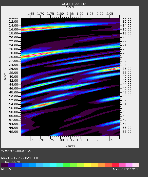
| Estimated Moho Depth: |
35.25 km |
| Estimated Crust Vp/Vs: |
2.10 |
| Assumed Crust Vp: |
6.498 km/s |
| Estimated Crust Vs: |
3.098 km/s |
| Estimated Crust Poisson's Ratio: |
0.35 |
|
| Radial Match: |
88.07727 % |
| Radial Bump: |
400 |
| Transverse Match: |
68.86503 % |
| Transverse Bump: |
400 |
| SOD ConfigId: |
3103472 |
| Insert Time: |
2018-11-09 16:53:54.473 +0000 |
| GWidth: |
2.5 |
| Max Bumps: |
400 |
| Tol: |
0.001 |
|

Signal To Noise
| Channel | StoN | STA | LTA |
| US:HDIL:00:BHZ:20181025T23:06:25.748997Z | 3.4843404 | 6.880278E-7 | 1.9746285E-7 |
| US:HDIL:00:BH1:20181025T23:06:25.748997Z | 0.8132083 | 2.3771662E-7 | 2.923195E-7 |
| US:HDIL:00:BH2:20181025T23:06:25.748997Z | 1.1007098 | 2.7726196E-7 | 2.518938E-7 |
| Arrivals |
| Ps | 6.1 SECOND |
| PpPs | 16 SECOND |
| PsPs/PpSs | 22 SECOND |


