You are here: Home > Network List > CN - Canadian National Seismograph Network Stations List
> Station INK INUVIK, NT > Earthquake Result Viewer
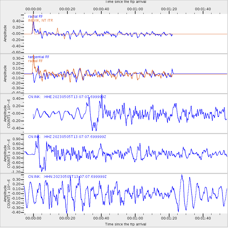
INK INUVIK, NT - Earthquake Result Viewer
*The percent match for this event was below the threshold and hence no stack was calculated.
| Earthquake location: |
Near West Coast Of Honshu, Japan |
| Earthquake latitude/longitude: |
37.5/137.3 |
| Earthquake time(UTC): |
2023/05/05 (125) 12:58:04 GMT |
| Earthquake Depth: |
14 km |
| Earthquake Magnitude: |
5.8 mb |
| Earthquake Catalog/Contributor: |
NEIC PDE/us |
|
| Network: |
CN Canadian National Seismograph Network |
| Station: |
INK INUVIK, NT |
| Lat/Lon: |
68.31 N/133.53 W |
| Elevation: |
44 m |
|
| Distance: |
55.5 deg |
| Az: |
26.825 deg |
| Baz: |
285.112 deg |
| Ray Param: |
$rayparam |
*The percent match for this event was below the threshold and hence was not used in the summary stack. |
|
| Radial Match: |
72.16086 % |
| Radial Bump: |
400 |
| Transverse Match: |
42.00647 % |
| Transverse Bump: |
400 |
| SOD ConfigId: |
30536071 |
| Insert Time: |
2023-05-19 13:14:32.413 +0000 |
| GWidth: |
2.5 |
| Max Bumps: |
400 |
| Tol: |
0.001 |
|
Signal To Noise
| Channel | StoN | STA | LTA |
| CN:INK: :HHZ:20230505T13:07:07.699999Z | 5.9491405 | 5.901319E-7 | 9.9196164E-8 |
| CN:INK: :HHN:20230505T13:07:07.699999Z | 0.98824215 | 1.3720614E-7 | 1.3883859E-7 |
| CN:INK: :HHE:20230505T13:07:07.699999Z | 3.2191174 | 2.2945518E-7 | 7.127891E-8 |
| Arrivals |
| Ps | |
| PpPs | |
| PsPs/PpSs | |


