You are here: Home > Network List > CB - China National Seismic Network Stations List
> Station WHN Wuhantai,Hubei Province > Earthquake Result Viewer
WHN Wuhantai,Hubei Province - Earthquake Result Viewer
| Earthquake location: |
Halmahera, Indonesia |
| Earthquake latitude/longitude: |
-1.7/128.1 |
| Earthquake time(UTC): |
2010/03/14 (073) 00:57:44 GMT |
| Earthquake Depth: |
53 km |
| Earthquake Magnitude: |
6.3 MB, 6.4 MW, 6.4 MW |
| Earthquake Catalog/Contributor: |
WHDF/NEIC |
|
| Network: |
CB China National Seismic Network |
| Station: |
WHN Wuhantai,Hubei Province |
| Lat/Lon: |
30.54 N/114.35 E |
| Elevation: |
80 m |
|
| Distance: |
34.6 deg |
| Az: |
338.806 deg |
| Baz: |
155.237 deg |
| Ray Param: |
0.077503204 |
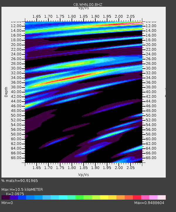
| Estimated Moho Depth: |
10.5 km |
| Estimated Crust Vp/Vs: |
2.10 |
| Assumed Crust Vp: |
6.276 km/s |
| Estimated Crust Vs: |
2.992 km/s |
| Estimated Crust Poisson's Ratio: |
0.35 |
|
| Radial Match: |
90.91965 % |
| Radial Bump: |
307 |
| Transverse Match: |
79.39366 % |
| Transverse Bump: |
400 |
| SOD ConfigId: |
308276 |
| Insert Time: |
2010-06-22 19:19:43.569 +0000 |
| GWidth: |
2.5 |
| Max Bumps: |
400 |
| Tol: |
0.001 |
|

Signal To Noise
| Channel | StoN | STA | LTA |
| CB:WHN:00:BHZ:20100314T01:03:58.638995Z | 24.84406 | 5.514538E-6 | 2.2196603E-7 |
| CB:WHN:00:BHN:20100314T01:03:58.640002Z | 12.735493 | 2.4338099E-6 | 1.9110449E-7 |
| CB:WHN:00:BHE:20100314T01:03:58.638995Z | 7.8452277 | 1.116373E-6 | 1.4229964E-7 |
| Arrivals |
| Ps | 2.0 SECOND |
| PpPs | 4.9 SECOND |
| PsPs/PpSs | 6.8 SECOND |


