You are here: Home > Network List > US - United States National Seismic Network Stations List
> Station OGNE Ogallala, Nebraska, USA > Earthquake Result Viewer
OGNE Ogallala, Nebraska, USA - Earthquake Result Viewer
| Earthquake location: |
Ionian Sea |
| Earthquake latitude/longitude: |
37.5/20.6 |
| Earthquake time(UTC): |
2018/10/25 (298) 22:54:52 GMT |
| Earthquake Depth: |
14 km |
| Earthquake Magnitude: |
6.8 Mww |
| Earthquake Catalog/Contributor: |
NEIC PDE/us |
|
| Network: |
US United States National Seismic Network |
| Station: |
OGNE Ogallala, Nebraska, USA |
| Lat/Lon: |
40.95 N/102.03 W |
| Elevation: |
1054 m |
|
| Distance: |
85.9 deg |
| Az: |
320.221 deg |
| Baz: |
42.193 deg |
| Ray Param: |
0.044421677 |
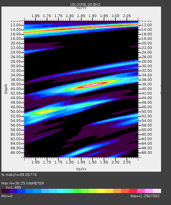
| Estimated Moho Depth: |
38.25 km |
| Estimated Crust Vp/Vs: |
1.89 |
| Assumed Crust Vp: |
6.483 km/s |
| Estimated Crust Vs: |
3.421 km/s |
| Estimated Crust Poisson's Ratio: |
0.31 |
|
| Radial Match: |
89.85776 % |
| Radial Bump: |
306 |
| Transverse Match: |
69.52257 % |
| Transverse Bump: |
342 |
| SOD ConfigId: |
3103472 |
| Insert Time: |
2018-11-09 16:54:16.379 +0000 |
| GWidth: |
2.5 |
| Max Bumps: |
400 |
| Tol: |
0.001 |
|
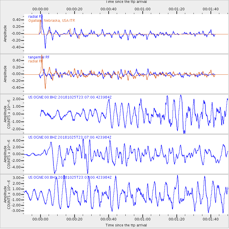
Signal To Noise
| Channel | StoN | STA | LTA |
| US:OGNE:00:BHZ:20181025T23:07:00.423984Z | 5.513156 | 7.749047E-7 | 1.4055556E-7 |
| US:OGNE:00:BH1:20181025T23:07:00.423984Z | 1.6607152 | 8.49151E-7 | 5.113164E-7 |
| US:OGNE:00:BH2:20181025T23:07:00.423984Z | 1.5567142 | 5.523754E-7 | 3.5483419E-7 |
| Arrivals |
| Ps | 5.4 SECOND |
| PpPs | 17 SECOND |
| PsPs/PpSs | 22 SECOND |


