You are here: Home > Network List > II - Global Seismograph Network (GSN - IRIS/IDA) Stations List
> Station ABKT Alibek, Turkmenistan > Earthquake Result Viewer
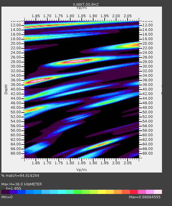
ABKT Alibek, Turkmenistan - Earthquake Result Viewer
| Earthquake location: |
Halmahera, Indonesia |
| Earthquake latitude/longitude: |
-1.7/128.1 |
| Earthquake time(UTC): |
2010/03/14 (073) 00:57:44 GMT |
| Earthquake Depth: |
53 km |
| Earthquake Magnitude: |
6.3 MB, 6.4 MW, 6.4 MW |
| Earthquake Catalog/Contributor: |
WHDF/NEIC |
|
| Network: |
II Global Seismograph Network (GSN - IRIS/IDA) |
| Station: |
ABKT Alibek, Turkmenistan |
| Lat/Lon: |
37.93 N/58.12 E |
| Elevation: |
678 m |
|
| Distance: |
75.4 deg |
| Az: |
309.829 deg |
| Baz: |
103.89 deg |
| Ray Param: |
0.051596507 |
| Estimated Moho Depth: |
36.0 km |
| Estimated Crust Vp/Vs: |
1.65 |
| Assumed Crust Vp: |
6.53 km/s |
| Estimated Crust Vs: |
3.946 km/s |
| Estimated Crust Poisson's Ratio: |
0.21 |
|
| Radial Match: |
94.816284 % |
| Radial Bump: |
400 |
| Transverse Match: |
91.659195 % |
| Transverse Bump: |
400 |
| SOD ConfigId: |
308276 |
| Insert Time: |
2010-06-22 19:20:26.142 +0000 |
| GWidth: |
2.5 |
| Max Bumps: |
400 |
| Tol: |
0.001 |
|

Signal To Noise
| Channel | StoN | STA | LTA |
| II:ABKT:00:BHZ:20100314T01:08:51.822009Z | 24.590105 | 1.3481348E-6 | 5.482428E-8 |
| II:ABKT:00:BHN:20100314T01:08:51.822009Z | 5.495455 | 2.2651633E-7 | 4.121885E-8 |
| II:ABKT:00:BHE:20100314T01:08:51.822009Z | 8.6537895 | 3.685553E-7 | 4.2588894E-8 |
| Arrivals |
| Ps | 3.7 SECOND |
| PpPs | 14 SECOND |
| PsPs/PpSs | 18 SECOND |


