You are here: Home > Network List > IU - Global Seismograph Network (GSN - IRIS/USGS) Stations List
> Station TIXI Tiksi, Russia > Earthquake Result Viewer
TIXI Tiksi, Russia - Earthquake Result Viewer
| Earthquake location: |
Halmahera, Indonesia |
| Earthquake latitude/longitude: |
-1.7/128.1 |
| Earthquake time(UTC): |
2010/03/14 (073) 00:57:44 GMT |
| Earthquake Depth: |
53 km |
| Earthquake Magnitude: |
6.3 MB, 6.4 MW, 6.4 MW |
| Earthquake Catalog/Contributor: |
WHDF/NEIC |
|
| Network: |
IU Global Seismograph Network (GSN - IRIS/USGS) |
| Station: |
TIXI Tiksi, Russia |
| Lat/Lon: |
71.63 N/128.87 E |
| Elevation: |
40 m |
|
| Distance: |
73.2 deg |
| Az: |
0.242 deg |
| Baz: |
180.764 deg |
| Ray Param: |
0.053057414 |
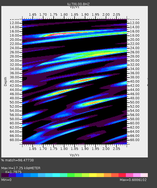
| Estimated Moho Depth: |
17.25 km |
| Estimated Crust Vp/Vs: |
1.80 |
| Assumed Crust Vp: |
6.552 km/s |
| Estimated Crust Vs: |
3.645 km/s |
| Estimated Crust Poisson's Ratio: |
0.28 |
|
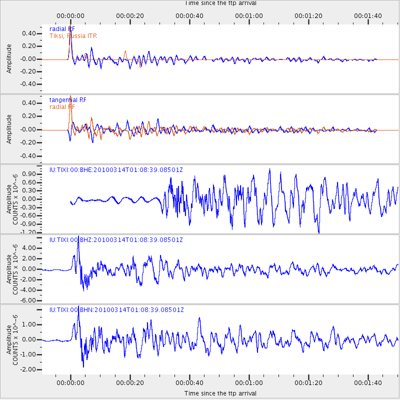
| Radial Match: |
96.47738 % |
| Radial Bump: |
400 |
| Transverse Match: |
94.10705 % |
| Transverse Bump: |
400 |
| SOD ConfigId: |
308276 |
| Insert Time: |
2010-06-22 19:20:41.288 +0000 |
| GWidth: |
2.5 |
| Max Bumps: |
400 |
| Tol: |
0.001 |
|
Signal To Noise
| Channel | StoN | STA | LTA |
| IU:TIXI:00:BHZ:20100314T01:08:39.08501Z | 28.450739 | 2.3050065E-6 | 8.101746E-8 |
| IU:TIXI:00:BHN:20100314T01:08:39.08501Z | 18.563559 | 8.831853E-7 | 4.7576293E-8 |
| IU:TIXI:00:BHE:20100314T01:08:39.08501Z | 4.986353 | 3.346478E-7 | 6.711274E-8 |
| Arrivals |
| Ps | 2.2 SECOND |
| PpPs | 7.1 SECOND |
| PsPs/PpSs | 9.3 SECOND |


