You are here: Home > Network List > KN - Kyrgyz Seismic Telemetry Network Stations List
> Station EKS2 KN.EKS2 > Earthquake Result Viewer
EKS2 KN.EKS2 - Earthquake Result Viewer
| Earthquake location: |
Halmahera, Indonesia |
| Earthquake latitude/longitude: |
-1.7/128.1 |
| Earthquake time(UTC): |
2010/03/14 (073) 00:57:44 GMT |
| Earthquake Depth: |
53 km |
| Earthquake Magnitude: |
6.3 MB, 6.4 MW, 6.4 MW |
| Earthquake Catalog/Contributor: |
WHDF/NEIC |
|
| Network: |
KN Kyrgyz Seismic Telemetry Network |
| Station: |
EKS2 KN.EKS2 |
| Lat/Lon: |
42.66 N/73.78 E |
| Elevation: |
1360 m |
|
| Distance: |
65.8 deg |
| Az: |
318.914 deg |
| Baz: |
117.057 deg |
| Ray Param: |
0.057916738 |
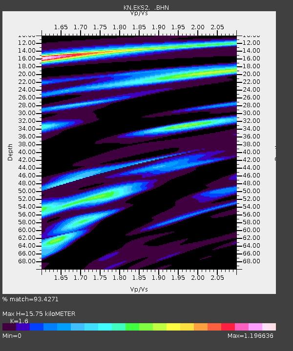
| Estimated Moho Depth: |
15.75 km |
| Estimated Crust Vp/Vs: |
1.60 |
| Assumed Crust Vp: |
6.316 km/s |
| Estimated Crust Vs: |
3.947 km/s |
| Estimated Crust Poisson's Ratio: |
0.18 |
|
| Radial Match: |
93.4271 % |
| Radial Bump: |
400 |
| Transverse Match: |
86.49833 % |
| Transverse Bump: |
400 |
| SOD ConfigId: |
308276 |
| Insert Time: |
2010-06-22 19:21:32.418 +0000 |
| GWidth: |
2.5 |
| Max Bumps: |
400 |
| Tol: |
0.001 |
|
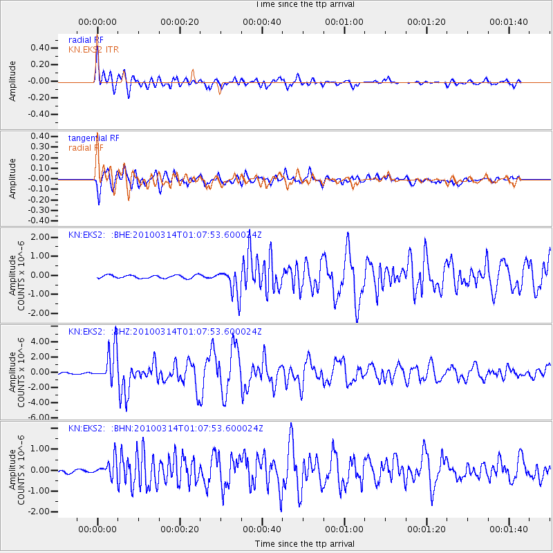
Signal To Noise
| Channel | StoN | STA | LTA |
| KN:EKS2: :BHZ:20100314T01:07:53.600024Z | 32.999123 | 2.3053155E-6 | 6.985991E-8 |
| KN:EKS2: :BHN:20100314T01:07:53.600024Z | 3.0970953 | 4.3907008E-7 | 1.4176834E-7 |
| KN:EKS2: :BHE:20100314T01:07:53.600024Z | 8.834284 | 7.163911E-7 | 8.109216E-8 |
| Arrivals |
| Ps | 1.6 SECOND |
| PpPs | 6.2 SECOND |
| PsPs/PpSs | 7.8 SECOND |


