You are here: Home > Network List > CI - Caltech Regional Seismic Network Stations List
> Station MPM Manuel Prospect Mine, California, USA > Earthquake Result Viewer
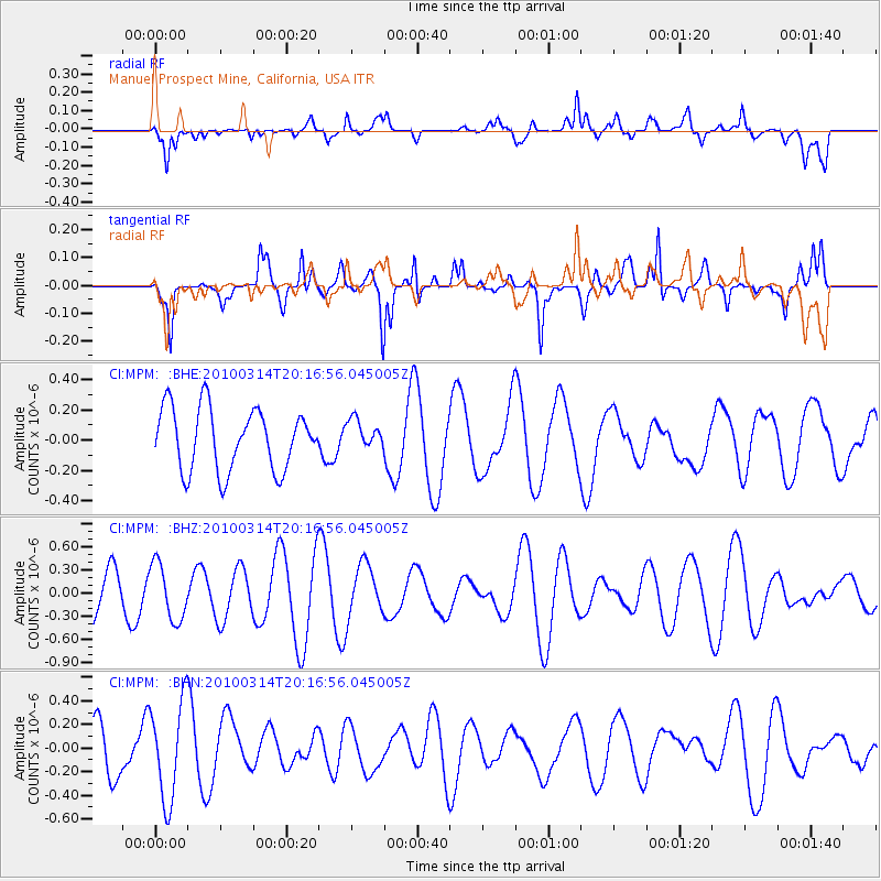
MPM Manuel Prospect Mine, California, USA - Earthquake Result Viewer
*The percent match for this event was below the threshold and hence no stack was calculated.
| Earthquake location: |
Near Coast Of Central Chile |
| Earthquake latitude/longitude: |
-38.5/-73.5 |
| Earthquake time(UTC): |
2010/03/14 (073) 20:04:54 GMT |
| Earthquake Depth: |
13 km |
| Earthquake Magnitude: |
5.5 MB, 5.4 MS, 5.6 MW, 5.4 MW |
| Earthquake Catalog/Contributor: |
WHDF/NEIC |
|
| Network: |
CI Caltech Regional Seismic Network |
| Station: |
MPM Manuel Prospect Mine, California, USA |
| Lat/Lon: |
36.06 N/117.49 W |
| Elevation: |
185 m |
|
| Distance: |
84.6 deg |
| Az: |
325.603 deg |
| Baz: |
146.849 deg |
| Ray Param: |
$rayparam |
*The percent match for this event was below the threshold and hence was not used in the summary stack. |
|
| Radial Match: |
37.003098 % |
| Radial Bump: |
400 |
| Transverse Match: |
65.556015 % |
| Transverse Bump: |
387 |
| SOD ConfigId: |
308276 |
| Insert Time: |
2010-06-22 19:33:43.680 +0000 |
| GWidth: |
2.5 |
| Max Bumps: |
400 |
| Tol: |
0.001 |
|
Signal To Noise
| Channel | StoN | STA | LTA |
| CI:MPM: :BHZ:20100314T20:16:56.045005Z | 1.8708364 | 3.635506E-7 | 1.9432518E-7 |
| CI:MPM: :BHN:20100314T20:16:56.045005Z | 1.9182943 | 4.1175542E-7 | 2.1464663E-7 |
| CI:MPM: :BHE:20100314T20:16:56.045005Z | 0.47567797 | 9.667488E-8 | 2.0323598E-7 |
| Arrivals |
| Ps | |
| PpPs | |
| PsPs/PpSs | |


