You are here: Home > Network List > TA - USArray Transportable Network (new EarthScope stations) Stations List
> Station R23A Moffat, CO, USA > Earthquake Result Viewer
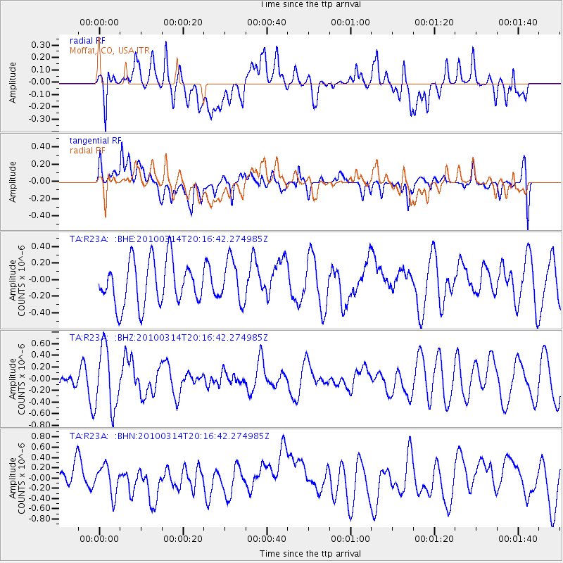
R23A Moffat, CO, USA - Earthquake Result Viewer
*The percent match for this event was below the threshold and hence no stack was calculated.
| Earthquake location: |
Near Coast Of Central Chile |
| Earthquake latitude/longitude: |
-38.5/-73.5 |
| Earthquake time(UTC): |
2010/03/14 (073) 20:04:54 GMT |
| Earthquake Depth: |
13 km |
| Earthquake Magnitude: |
5.5 MB, 5.4 MS, 5.6 MW, 5.4 MW |
| Earthquake Catalog/Contributor: |
WHDF/NEIC |
|
| Network: |
TA USArray Transportable Network (new EarthScope stations) |
| Station: |
R23A Moffat, CO, USA |
| Lat/Lon: |
38.19 N/105.83 W |
| Elevation: |
2547 m |
|
| Distance: |
81.9 deg |
| Az: |
334.838 deg |
| Baz: |
154.961 deg |
| Ray Param: |
$rayparam |
*The percent match for this event was below the threshold and hence was not used in the summary stack. |
|
| Radial Match: |
48.869953 % |
| Radial Bump: |
400 |
| Transverse Match: |
58.02954 % |
| Transverse Bump: |
400 |
| SOD ConfigId: |
308276 |
| Insert Time: |
2010-06-22 19:37:24.937 +0000 |
| GWidth: |
2.5 |
| Max Bumps: |
400 |
| Tol: |
0.001 |
|
Signal To Noise
| Channel | StoN | STA | LTA |
| TA:R23A: :BHZ:20100314T20:16:42.274985Z | 2.8094993 | 5.240802E-7 | 1.8653864E-7 |
| TA:R23A: :BHN:20100314T20:16:42.274985Z | 1.3403493 | 2.87429E-7 | 2.1444336E-7 |
| TA:R23A: :BHE:20100314T20:16:42.274985Z | 0.98082453 | 2.613525E-7 | 2.6646205E-7 |
| Arrivals |
| Ps | |
| PpPs | |
| PsPs/PpSs | |


