You are here: Home > Network List > TA - USArray Transportable Network (new EarthScope stations) Stations List
> Station O27A Beecher Island, Eckley, CO, USA > Earthquake Result Viewer
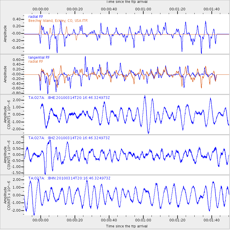
O27A Beecher Island, Eckley, CO, USA - Earthquake Result Viewer
*The percent match for this event was below the threshold and hence no stack was calculated.
| Earthquake location: |
Near Coast Of Central Chile |
| Earthquake latitude/longitude: |
-38.5/-73.5 |
| Earthquake time(UTC): |
2010/03/14 (073) 20:04:54 GMT |
| Earthquake Depth: |
13 km |
| Earthquake Magnitude: |
5.5 MB, 5.4 MS, 5.6 MW, 5.4 MW |
| Earthquake Catalog/Contributor: |
WHDF/NEIC |
|
| Network: |
TA USArray Transportable Network (new EarthScope stations) |
| Station: |
O27A Beecher Island, Eckley, CO, USA |
| Lat/Lon: |
40.19 N/102.48 W |
| Elevation: |
1206 m |
|
| Distance: |
82.7 deg |
| Az: |
338.051 deg |
| Baz: |
157.498 deg |
| Ray Param: |
$rayparam |
*The percent match for this event was below the threshold and hence was not used in the summary stack. |
|
| Radial Match: |
61.812927 % |
| Radial Bump: |
268 |
| Transverse Match: |
70.7864 % |
| Transverse Bump: |
280 |
| SOD ConfigId: |
308276 |
| Insert Time: |
2010-06-22 19:37:43.901 +0000 |
| GWidth: |
2.5 |
| Max Bumps: |
400 |
| Tol: |
0.001 |
|
Signal To Noise
| Channel | StoN | STA | LTA |
| TA:O27A: :BHZ:20100314T20:16:46.324973Z | 2.0524018 | 7.3429754E-7 | 3.5777475E-7 |
| TA:O27A: :BHN:20100314T20:16:46.324973Z | 0.94596577 | 8.393172E-7 | 8.872596E-7 |
| TA:O27A: :BHE:20100314T20:16:46.324973Z | 1.0702152 | 7.302307E-7 | 6.8232134E-7 |
| Arrivals |
| Ps | |
| PpPs | |
| PsPs/PpSs | |


