You are here: Home > Network List > TA - USArray Transportable Network (new EarthScope stations) Stations List
> Station 431A Sonora, TX, USA > Earthquake Result Viewer
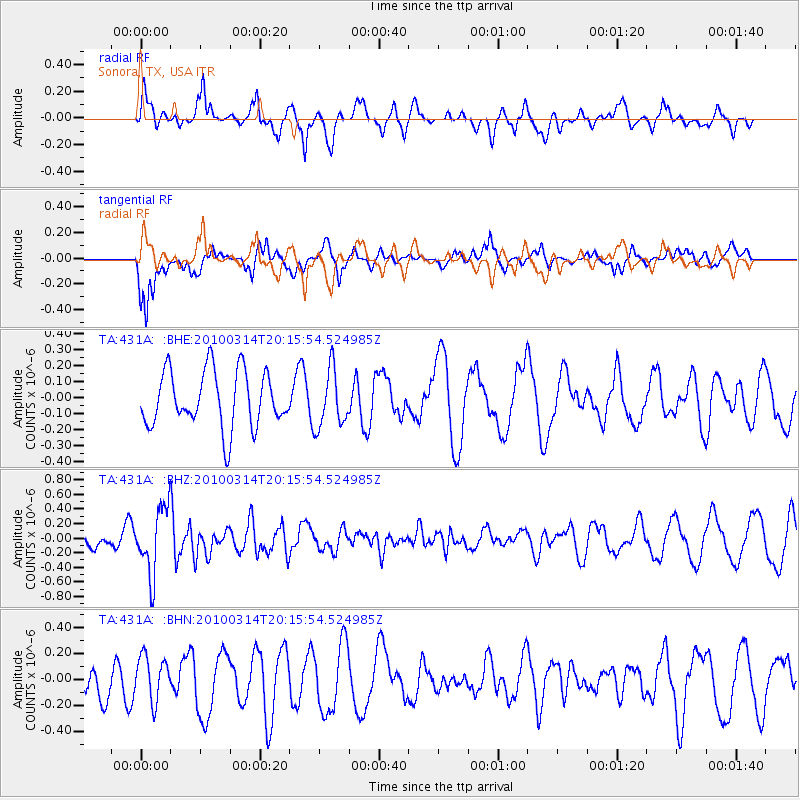
431A Sonora, TX, USA - Earthquake Result Viewer
*The percent match for this event was below the threshold and hence no stack was calculated.
| Earthquake location: |
Near Coast Of Central Chile |
| Earthquake latitude/longitude: |
-38.5/-73.5 |
| Earthquake time(UTC): |
2010/03/14 (073) 20:04:54 GMT |
| Earthquake Depth: |
13 km |
| Earthquake Magnitude: |
5.5 MB, 5.4 MS, 5.6 MW, 5.4 MW |
| Earthquake Catalog/Contributor: |
WHDF/NEIC |
|
| Network: |
TA USArray Transportable Network (new EarthScope stations) |
| Station: |
431A Sonora, TX, USA |
| Lat/Lon: |
30.68 N/100.61 W |
| Elevation: |
700 m |
|
| Distance: |
73.3 deg |
| Az: |
335.84 deg |
| Baz: |
158.122 deg |
| Ray Param: |
$rayparam |
*The percent match for this event was below the threshold and hence was not used in the summary stack. |
|
| Radial Match: |
61.92529 % |
| Radial Bump: |
384 |
| Transverse Match: |
66.072685 % |
| Transverse Bump: |
400 |
| SOD ConfigId: |
308276 |
| Insert Time: |
2010-06-22 19:38:52.573 +0000 |
| GWidth: |
2.5 |
| Max Bumps: |
400 |
| Tol: |
0.001 |
|
Signal To Noise
| Channel | StoN | STA | LTA |
| TA:431A: :BHZ:20100314T20:15:54.524985Z | 2.9999866 | 4.5311864E-7 | 1.5104021E-7 |
| TA:431A: :BHN:20100314T20:15:54.524985Z | 1.4329787 | 1.7223408E-7 | 1.2019305E-7 |
| TA:431A: :BHE:20100314T20:15:54.524985Z | 1.0210541 | 1.7863391E-7 | 1.7495049E-7 |
| Arrivals |
| Ps | |
| PpPs | |
| PsPs/PpSs | |


