You are here: Home > Network List > GS - US Geological Survey Networks Stations List
> Station KAN10 Keim Farm > Earthquake Result Viewer
KAN10 Keim Farm - Earthquake Result Viewer
| Earthquake location: |
Near East Coast Of Honshu, Japan |
| Earthquake latitude/longitude: |
38.3/141.8 |
| Earthquake time(UTC): |
2018/10/25 (298) 18:36:09 GMT |
| Earthquake Depth: |
40 km |
| Earthquake Magnitude: |
5.7 Mww |
| Earthquake Catalog/Contributor: |
NEIC PDE/us |
|
| Network: |
GS US Geological Survey Networks |
| Station: |
KAN10 Keim Farm |
| Lat/Lon: |
37.12 N/98.10 W |
| Elevation: |
417 m |
|
| Distance: |
86.8 deg |
| Az: |
43.823 deg |
| Baz: |
317.042 deg |
| Ray Param: |
0.043716714 |
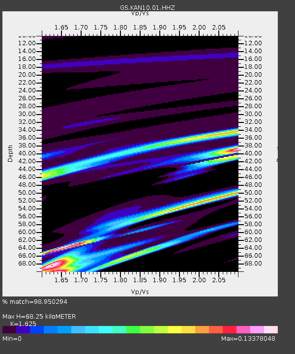
| Estimated Moho Depth: |
68.25 km |
| Estimated Crust Vp/Vs: |
1.62 |
| Assumed Crust Vp: |
6.426 km/s |
| Estimated Crust Vs: |
3.955 km/s |
| Estimated Crust Poisson's Ratio: |
0.20 |
|
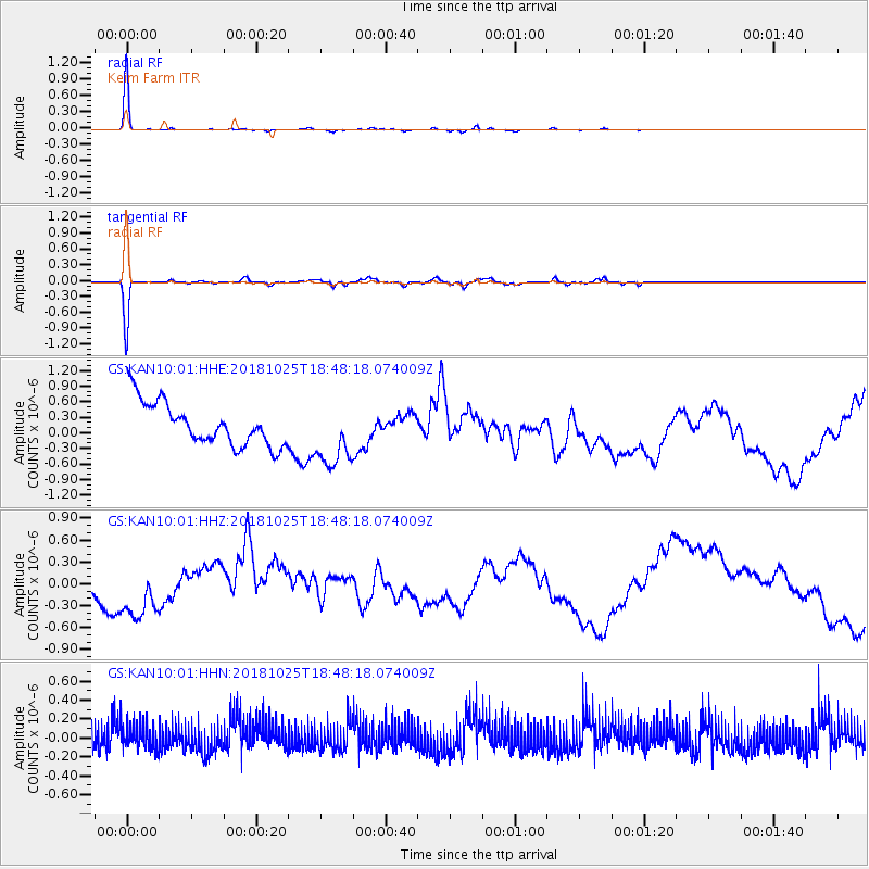
| Radial Match: |
98.950294 % |
| Radial Bump: |
108 |
| Transverse Match: |
96.87096 % |
| Transverse Bump: |
258 |
| SOD ConfigId: |
3103472 |
| Insert Time: |
2018-11-09 16:57:10.942 +0000 |
| GWidth: |
2.5 |
| Max Bumps: |
400 |
| Tol: |
0.001 |
|
Signal To Noise
| Channel | StoN | STA | LTA |
| GS:KAN10:01:HHZ:20181025T18:48:18.074009Z | 1.5463461 | 4.619867E-7 | 2.9876023E-7 |
| GS:KAN10:01:HHN:20181025T18:48:18.074009Z | 0.87340283 | 1.2374076E-7 | 1.4167662E-7 |
| GS:KAN10:01:HHE:20181025T18:48:18.074009Z | 1.5067093 | 6.2966944E-7 | 4.1791037E-7 |
| Arrivals |
| Ps | 6.8 SECOND |
| PpPs | 27 SECOND |
| PsPs/PpSs | 34 SECOND |


