You are here: Home > Network List > AK - Alaska Regional Network Stations List
> Station E27K Coleen River, AK, USA > Earthquake Result Viewer
E27K Coleen River, AK, USA - Earthquake Result Viewer
| Earthquake location: |
Hokkaido, Japan Region |
| Earthquake latitude/longitude: |
41.5/142.0 |
| Earthquake time(UTC): |
2023/05/05 (125) 17:47:15 GMT |
| Earthquake Depth: |
53 km |
| Earthquake Magnitude: |
5.9 Mww |
| Earthquake Catalog/Contributor: |
NEIC PDE/us |
|
| Network: |
AK Alaska Regional Network |
| Station: |
E27K Coleen River, AK, USA |
| Lat/Lon: |
68.19 N/141.60 W |
| Elevation: |
654 m |
|
| Distance: |
47.3 deg |
| Az: |
29.633 deg |
| Baz: |
276.513 deg |
| Ray Param: |
0.06994208 |
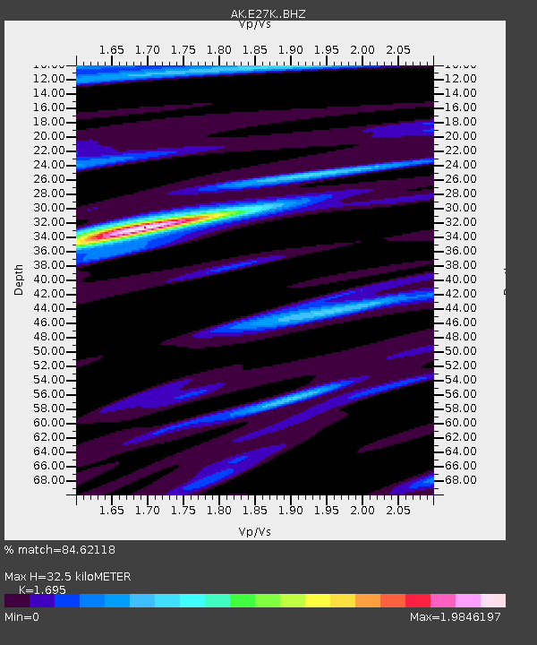
| Estimated Moho Depth: |
32.5 km |
| Estimated Crust Vp/Vs: |
1.70 |
| Assumed Crust Vp: |
6.522 km/s |
| Estimated Crust Vs: |
3.848 km/s |
| Estimated Crust Poisson's Ratio: |
0.23 |
|
| Radial Match: |
84.62118 % |
| Radial Bump: |
365 |
| Transverse Match: |
52.67428 % |
| Transverse Bump: |
383 |
| SOD ConfigId: |
30536071 |
| Insert Time: |
2023-05-19 17:50:20.828 +0000 |
| GWidth: |
2.5 |
| Max Bumps: |
400 |
| Tol: |
0.001 |
|

Signal To Noise
| Channel | StoN | STA | LTA |
| AK:E27K: :BHZ:20230505T17:55:13.299997Z | 5.9528656 | 3.3305386E-7 | 5.5948494E-8 |
| AK:E27K: :BHN:20230505T17:55:13.299997Z | 1.311003 | 1.2175018E-7 | 9.286796E-8 |
| AK:E27K: :BHE:20230505T17:55:13.299997Z | 5.214939 | 2.9492313E-7 | 5.6553514E-8 |
| Arrivals |
| Ps | 3.7 SECOND |
| PpPs | 13 SECOND |
| PsPs/PpSs | 16 SECOND |


