You are here: Home > Network List > US - United States National Seismic Network Stations List
> Station EGMT Eagleton, Montana, USA > Earthquake Result Viewer
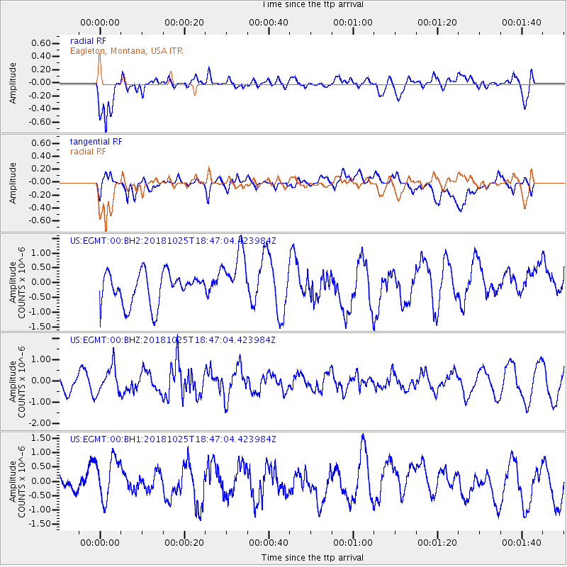
EGMT Eagleton, Montana, USA - Earthquake Result Viewer
*The percent match for this event was below the threshold and hence no stack was calculated.
| Earthquake location: |
Near East Coast Of Honshu, Japan |
| Earthquake latitude/longitude: |
38.3/141.8 |
| Earthquake time(UTC): |
2018/10/25 (298) 18:36:09 GMT |
| Earthquake Depth: |
40 km |
| Earthquake Magnitude: |
5.7 Mww |
| Earthquake Catalog/Contributor: |
NEIC PDE/us |
|
| Network: |
US United States National Seismic Network |
| Station: |
EGMT Eagleton, Montana, USA |
| Lat/Lon: |
48.02 N/109.75 W |
| Elevation: |
1055 m |
|
| Distance: |
73.1 deg |
| Az: |
41.716 deg |
| Baz: |
308.762 deg |
| Ray Param: |
$rayparam |
*The percent match for this event was below the threshold and hence was not used in the summary stack. |
|
| Radial Match: |
74.91812 % |
| Radial Bump: |
400 |
| Transverse Match: |
53.1535 % |
| Transverse Bump: |
400 |
| SOD ConfigId: |
3103472 |
| Insert Time: |
2018-11-09 16:59:40.831 +0000 |
| GWidth: |
2.5 |
| Max Bumps: |
400 |
| Tol: |
0.001 |
|
Signal To Noise
| Channel | StoN | STA | LTA |
| US:EGMT:00:BHZ:20181025T18:47:04.423984Z | 1.7876714 | 6.1349004E-7 | 3.431783E-7 |
| US:EGMT:00:BH1:20181025T18:47:04.423984Z | 1.8233104 | 7.962844E-7 | 4.3672452E-7 |
| US:EGMT:00:BH2:20181025T18:47:04.423984Z | 1.7657309 | 9.409921E-7 | 5.3291933E-7 |
| Arrivals |
| Ps | |
| PpPs | |
| PsPs/PpSs | |


