You are here: Home > Network List > TA - USArray Transportable Network (new EarthScope stations) Stations List
> Station 633A Saathoff Ranch, Hondo, TX, USA > Earthquake Result Viewer
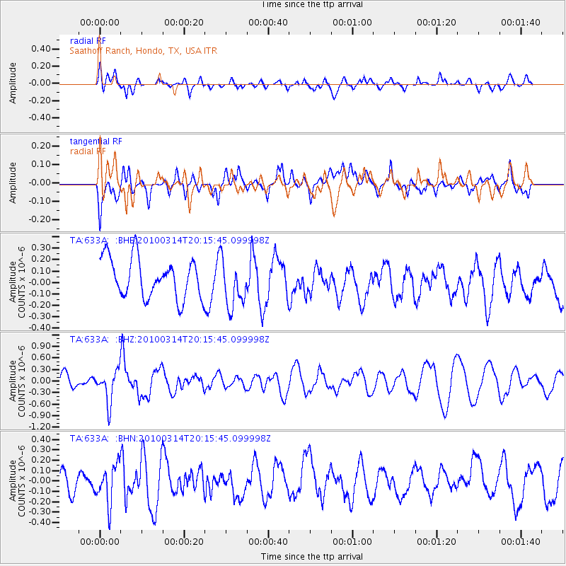
633A Saathoff Ranch, Hondo, TX, USA - Earthquake Result Viewer
*The percent match for this event was below the threshold and hence no stack was calculated.
| Earthquake location: |
Near Coast Of Central Chile |
| Earthquake latitude/longitude: |
-38.5/-73.5 |
| Earthquake time(UTC): |
2010/03/14 (073) 20:04:54 GMT |
| Earthquake Depth: |
13 km |
| Earthquake Magnitude: |
5.5 MB, 5.4 MS, 5.6 MW, 5.4 MW |
| Earthquake Catalog/Contributor: |
WHDF/NEIC |
|
| Network: |
TA USArray Transportable Network (new EarthScope stations) |
| Station: |
633A Saathoff Ranch, Hondo, TX, USA |
| Lat/Lon: |
29.46 N/99.18 W |
| Elevation: |
320 m |
|
| Distance: |
71.8 deg |
| Az: |
336.584 deg |
| Baz: |
159.059 deg |
| Ray Param: |
$rayparam |
*The percent match for this event was below the threshold and hence was not used in the summary stack. |
|
| Radial Match: |
53.510715 % |
| Radial Bump: |
400 |
| Transverse Match: |
54.67174 % |
| Transverse Bump: |
400 |
| SOD ConfigId: |
308276 |
| Insert Time: |
2010-06-22 19:44:06.952 +0000 |
| GWidth: |
2.5 |
| Max Bumps: |
400 |
| Tol: |
0.001 |
|
Signal To Noise
| Channel | StoN | STA | LTA |
| TA:633A: :BHZ:20100314T20:15:45.099998Z | 1.7101586 | 4.329245E-7 | 2.5314876E-7 |
| TA:633A: :BHN:20100314T20:15:45.099998Z | 1.9908507 | 1.9105498E-7 | 9.59665E-8 |
| TA:633A: :BHE:20100314T20:15:45.099998Z | 1.1812146 | 2.0287963E-7 | 1.717551E-7 |
| Arrivals |
| Ps | |
| PpPs | |
| PsPs/PpSs | |


