You are here: Home > Network List > IW - Intermountain West Stations List
> Station MOOW Moose Ponds, Wyoming, USA > Earthquake Result Viewer
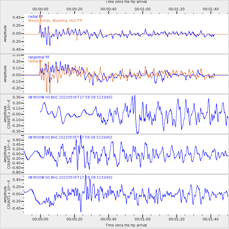
MOOW Moose Ponds, Wyoming, USA - Earthquake Result Viewer
*The percent match for this event was below the threshold and hence no stack was calculated.
| Earthquake location: |
Hokkaido, Japan Region |
| Earthquake latitude/longitude: |
41.5/142.0 |
| Earthquake time(UTC): |
2023/05/05 (125) 17:47:15 GMT |
| Earthquake Depth: |
53 km |
| Earthquake Magnitude: |
5.9 Mww |
| Earthquake Catalog/Contributor: |
NEIC PDE/us |
|
| Network: |
IW Intermountain West |
| Station: |
MOOW Moose Ponds, Wyoming, USA |
| Lat/Lon: |
43.75 N/110.74 W |
| Elevation: |
2128 m |
|
| Distance: |
72.9 deg |
| Az: |
46.371 deg |
| Baz: |
311.4 deg |
| Ray Param: |
$rayparam |
*The percent match for this event was below the threshold and hence was not used in the summary stack. |
|
| Radial Match: |
49.9665 % |
| Radial Bump: |
400 |
| Transverse Match: |
44.790558 % |
| Transverse Bump: |
400 |
| SOD ConfigId: |
30536071 |
| Insert Time: |
2023-05-19 18:04:33.475 +0000 |
| GWidth: |
2.5 |
| Max Bumps: |
400 |
| Tol: |
0.001 |
|
Signal To Noise
| Channel | StoN | STA | LTA |
| IW:MOOW:00:BHZ:20230505T17:58:08.523996Z | 0.7647475 | 1.4198937E-7 | 1.856683E-7 |
| IW:MOOW:00:BH1:20230505T17:58:08.523996Z | 2.0399604 | 2.553375E-7 | 1.2516787E-7 |
| IW:MOOW:00:BH2:20230505T17:58:08.523996Z | 0.6653264 | 5.2623886E-8 | 7.909484E-8 |
| Arrivals |
| Ps | |
| PpPs | |
| PsPs/PpSs | |


