You are here: Home > Network List > GM - US Geological Survey Networks Stations List
> Station IWM01 Jericho 2M Well Monitoring Station > Earthquake Result Viewer
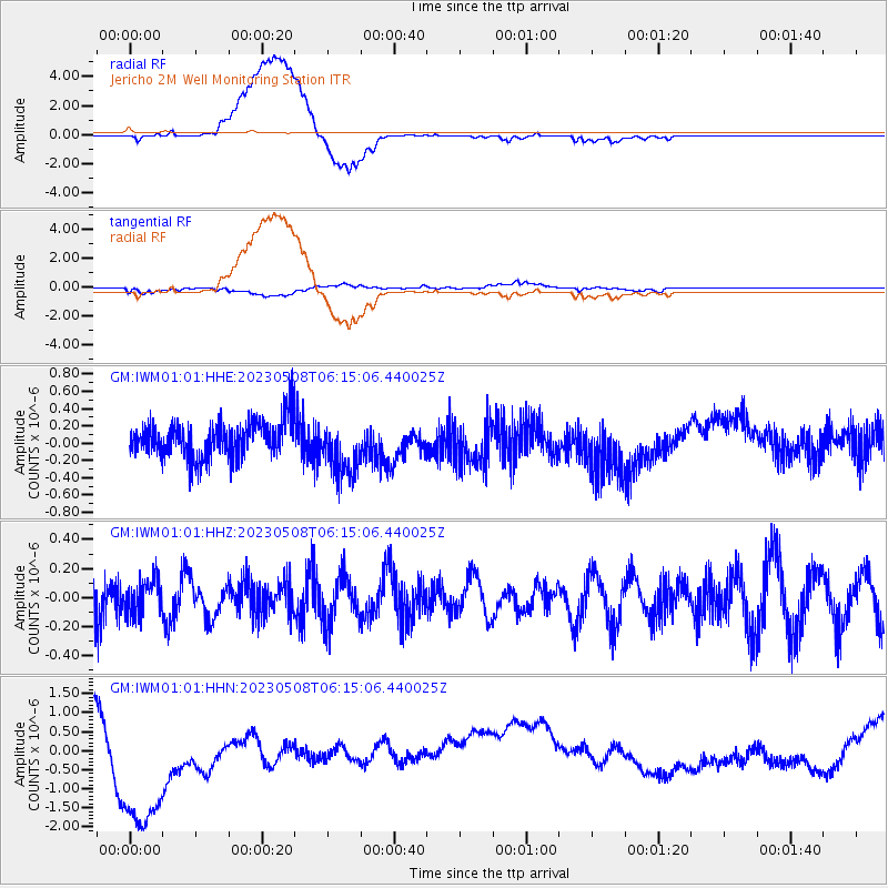
IWM01 Jericho 2M Well Monitoring Station - Earthquake Result Viewer
*The percent match for this event was below the threshold and hence no stack was calculated.
| Earthquake location: |
Southern East Pacific Rise |
| Earthquake latitude/longitude: |
-56.1/-121.4 |
| Earthquake time(UTC): |
2023/05/08 (128) 06:02:16 GMT |
| Earthquake Depth: |
10 km |
| Earthquake Magnitude: |
5.8 Mww |
| Earthquake Catalog/Contributor: |
NEIC PDE/us |
|
| Network: |
GM US Geological Survey Networks |
| Station: |
IWM01 Jericho 2M Well Monitoring Station |
| Lat/Lon: |
36.73 N/96.53 W |
| Elevation: |
328 m |
|
| Distance: |
94.8 deg |
| Az: |
19.811 deg |
| Baz: |
193.688 deg |
| Ray Param: |
$rayparam |
*The percent match for this event was below the threshold and hence was not used in the summary stack. |
|
| Radial Match: |
53.83439 % |
| Radial Bump: |
400 |
| Transverse Match: |
38.75865 % |
| Transverse Bump: |
400 |
| SOD ConfigId: |
30536071 |
| Insert Time: |
2023-05-22 06:09:10.180 +0000 |
| GWidth: |
2.5 |
| Max Bumps: |
400 |
| Tol: |
0.001 |
|
Signal To Noise
| Channel | StoN | STA | LTA |
| GM:IWM01:01:HHZ:20230508T06:15:06.440025Z | 0.7033498 | 1.1879569E-7 | 1.6889986E-7 |
| GM:IWM01:01:HHN:20230508T06:15:06.440025Z | 3.973263 | 2.269387E-6 | 5.711646E-7 |
| GM:IWM01:01:HHE:20230508T06:15:06.440025Z | 1.4795573 | 3.1687898E-7 | 2.1417148E-7 |
| Arrivals |
| Ps | |
| PpPs | |
| PsPs/PpSs | |


