You are here: Home > Network List > IU - Global Seismograph Network (GSN - IRIS/USGS) Stations List
> Station PMG Port Moresby, New Guinea > Earthquake Result Viewer
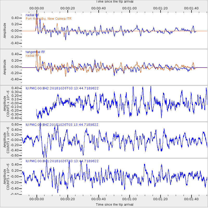
PMG Port Moresby, New Guinea - Earthquake Result Viewer
*The percent match for this event was below the threshold and hence no stack was calculated.
| Earthquake location: |
Hokkaido, Japan Region |
| Earthquake latitude/longitude: |
44.5/145.4 |
| Earthquake time(UTC): |
2018/10/26 (299) 03:04:53 GMT |
| Earthquake Depth: |
10 km |
| Earthquake Magnitude: |
5.6 Mww |
| Earthquake Catalog/Contributor: |
NEIC PDE/us |
|
| Network: |
IU Global Seismograph Network (GSN - IRIS/USGS) |
| Station: |
PMG Port Moresby, New Guinea |
| Lat/Lon: |
9.40 S/147.16 E |
| Elevation: |
90 m |
|
| Distance: |
53.7 deg |
| Az: |
177.847 deg |
| Baz: |
358.44 deg |
| Ray Param: |
$rayparam |
*The percent match for this event was below the threshold and hence was not used in the summary stack. |
|
| Radial Match: |
72.17674 % |
| Radial Bump: |
400 |
| Transverse Match: |
47.41642 % |
| Transverse Bump: |
400 |
| SOD ConfigId: |
3103472 |
| Insert Time: |
2018-11-09 17:03:25.297 +0000 |
| GWidth: |
2.5 |
| Max Bumps: |
400 |
| Tol: |
0.001 |
|
Signal To Noise
| Channel | StoN | STA | LTA |
| IU:PMG:00:BHZ:20181026T03:13:44.718982Z | 3.7106142 | 3.4277872E-7 | 9.237789E-8 |
| IU:PMG:00:BH1:20181026T03:13:44.718982Z | 1.5212219 | 1.617805E-7 | 1.0634905E-7 |
| IU:PMG:00:BH2:20181026T03:13:44.718982Z | 1.0578922 | 1.5763197E-7 | 1.490057E-7 |
| Arrivals |
| Ps | |
| PpPs | |
| PsPs/PpSs | |


