You are here: Home > Network List > TA - USArray Transportable Network (new EarthScope stations) Stations List
> Station BRSD Miller, SD, USA > Earthquake Result Viewer
BRSD Miller, SD, USA - Earthquake Result Viewer
*The percent match for this event was below the threshold and hence no stack was calculated.
| Earthquake location: |
Off Coast Of Central Chile |
| Earthquake latitude/longitude: |
-35.8/-73.2 |
| Earthquake time(UTC): |
2010/03/15 (074) 11:08:28 GMT |
| Earthquake Depth: |
14 km |
| Earthquake Magnitude: |
5.9 MB, 6.1 MS, 6.2 MW, 6.1 MW |
| Earthquake Catalog/Contributor: |
WHDF/NEIC |
|
| Network: |
TA USArray Transportable Network (new EarthScope stations) |
| Station: |
BRSD Miller, SD, USA |
| Lat/Lon: |
44.44 N/98.96 W |
| Elevation: |
519 m |
|
| Distance: |
83.2 deg |
| Az: |
341.704 deg |
| Baz: |
159.129 deg |
| Ray Param: |
$rayparam |
*The percent match for this event was below the threshold and hence was not used in the summary stack. |
|
| Radial Match: |
64.24123 % |
| Radial Bump: |
400 |
| Transverse Match: |
59.887577 % |
| Transverse Bump: |
400 |
| SOD ConfigId: |
308276 |
| Insert Time: |
2010-06-22 19:56:42.936 +0000 |
| GWidth: |
2.5 |
| Max Bumps: |
400 |
| Tol: |
0.001 |
|
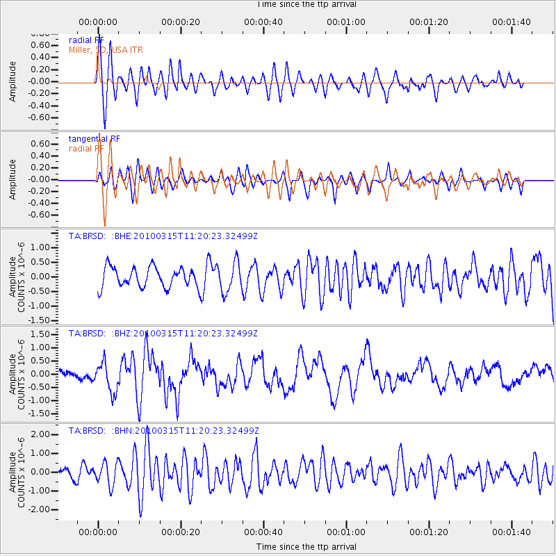
Signal To Noise
| Channel | StoN | STA | LTA |
| TA:BRSD: :BHZ:20100315T11:20:23.32499Z | 2.267859 | 5.727196E-7 | 2.5253757E-7 |
| TA:BRSD: :BHN:20100315T11:20:23.32499Z | 1.3047887 | 6.022266E-7 | 4.6155105E-7 |
| TA:BRSD: :BHE:20100315T11:20:23.32499Z | 1.5220963 | 5.1429964E-7 | 3.3788905E-7 |
| Arrivals |
| Ps | |
| PpPs | |
| PsPs/PpSs | |


