You are here: Home > Network List > 1E - GSC-BCOGC Induced Seismicity Study Stations List
> Station MONT9 Z > Earthquake Result Viewer
MONT9 Z - Earthquake Result Viewer
| Earthquake location: |
Tonga Islands |
| Earthquake latitude/longitude: |
-15.6/-174.6 |
| Earthquake time(UTC): |
2023/05/10 (130) 16:02:00 GMT |
| Earthquake Depth: |
210 km |
| Earthquake Magnitude: |
7.6 mww |
| Earthquake Catalog/Contributor: |
NEIC PDE/us |
|
| Network: |
1E GSC-BCOGC Induced Seismicity Study |
| Station: |
MONT9 Z |
| Lat/Lon: |
55.80 N/120.54 W |
| Elevation: |
832 m |
|
| Distance: |
84.3 deg |
| Az: |
27.35 deg |
| Baz: |
231.637 deg |
| Ray Param: |
0.045049533 |
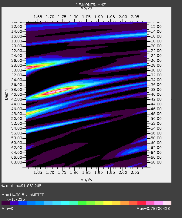
| Estimated Moho Depth: |
38.5 km |
| Estimated Crust Vp/Vs: |
1.72 |
| Assumed Crust Vp: |
6.303 km/s |
| Estimated Crust Vs: |
3.659 km/s |
| Estimated Crust Poisson's Ratio: |
0.25 |
|
| Radial Match: |
91.851265 % |
| Radial Bump: |
400 |
| Transverse Match: |
57.09889 % |
| Transverse Bump: |
400 |
| SOD ConfigId: |
30536071 |
| Insert Time: |
2023-05-24 16:02:59.542 +0000 |
| GWidth: |
2.5 |
| Max Bumps: |
400 |
| Tol: |
0.001 |
|

Signal To Noise
| Channel | StoN | STA | LTA |
| 1E:MONT9: :HHZ:20230510T16:13:37.549999Z | 19.633608 | 8.859345E-6 | 4.512337E-7 |
| 1E:MONT9: :HHN:20230510T16:13:37.549999Z | 2.3798072 | 2.2648671E-6 | 9.5170185E-7 |
| 1E:MONT9: :HHE:20230510T16:13:37.549999Z | 5.19993 | 2.140272E-6 | 4.1159632E-7 |
| Arrivals |
| Ps | 4.5 SECOND |
| PpPs | 16 SECOND |
| PsPs/PpSs | 21 SECOND |


