You are here: Home > Network List > AG - Arkansas Seismic Network Stations List
> Station XB03 El Dorado Temporary Station XB03 > Earthquake Result Viewer
XB03 El Dorado Temporary Station XB03 - Earthquake Result Viewer
| Earthquake location: |
Tonga Islands |
| Earthquake latitude/longitude: |
-15.6/-174.6 |
| Earthquake time(UTC): |
2023/05/10 (130) 16:02:00 GMT |
| Earthquake Depth: |
210 km |
| Earthquake Magnitude: |
7.6 mww |
| Earthquake Catalog/Contributor: |
NEIC PDE/us |
|
| Network: |
AG Arkansas Seismic Network |
| Station: |
XB03 El Dorado Temporary Station XB03 |
| Lat/Lon: |
36.48 N/90.87 W |
| Elevation: |
144 m |
|
| Distance: |
94.2 deg |
| Az: |
53.45 deg |
| Baz: |
253.838 deg |
| Ray Param: |
0.04094342 |
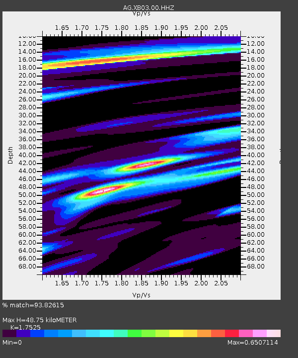
| Estimated Moho Depth: |
48.75 km |
| Estimated Crust Vp/Vs: |
1.75 |
| Assumed Crust Vp: |
6.53 km/s |
| Estimated Crust Vs: |
3.726 km/s |
| Estimated Crust Poisson's Ratio: |
0.26 |
|
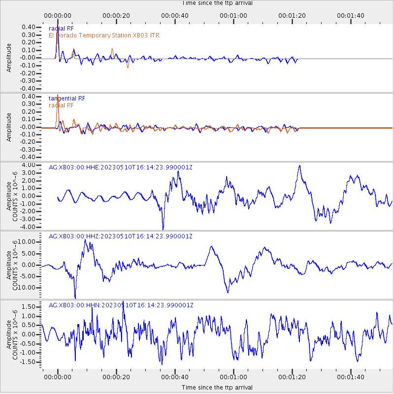
| Radial Match: |
93.82615 % |
| Radial Bump: |
400 |
| Transverse Match: |
74.72209 % |
| Transverse Bump: |
400 |
| SOD ConfigId: |
30536071 |
| Insert Time: |
2023-05-24 16:04:03.059 +0000 |
| GWidth: |
2.5 |
| Max Bumps: |
400 |
| Tol: |
0.001 |
|
Signal To Noise
| Channel | StoN | STA | LTA |
| AG:XB03:00:HHZ:20230510T16:14:23.990001Z | 5.868885 | 2.477958E-6 | 4.2221956E-7 |
| AG:XB03:00:HHN:20230510T16:14:23.990001Z | 1.0844215 | 2.9779147E-7 | 2.7460857E-7 |
| AG:XB03:00:HHE:20230510T16:14:23.990001Z | 1.2997639 | 5.292444E-7 | 4.07185E-7 |
| Arrivals |
| Ps | 5.7 SECOND |
| PpPs | 20 SECOND |
| PsPs/PpSs | 26 SECOND |


