You are here: Home > Network List > AK - Alaska Regional Network Stations List
> Station CAST Castle Rocks > Earthquake Result Viewer
CAST Castle Rocks - Earthquake Result Viewer
| Earthquake location: |
Tonga Islands |
| Earthquake latitude/longitude: |
-15.6/-174.6 |
| Earthquake time(UTC): |
2023/05/10 (130) 16:02:00 GMT |
| Earthquake Depth: |
210 km |
| Earthquake Magnitude: |
7.6 mww |
| Earthquake Catalog/Contributor: |
NEIC PDE/us |
|
| Network: |
AK Alaska Regional Network |
| Station: |
CAST Castle Rocks |
| Lat/Lon: |
63.42 N/152.08 W |
| Elevation: |
611 m |
|
| Distance: |
80.7 deg |
| Az: |
10.058 deg |
| Baz: |
201.968 deg |
| Ray Param: |
0.04758542 |
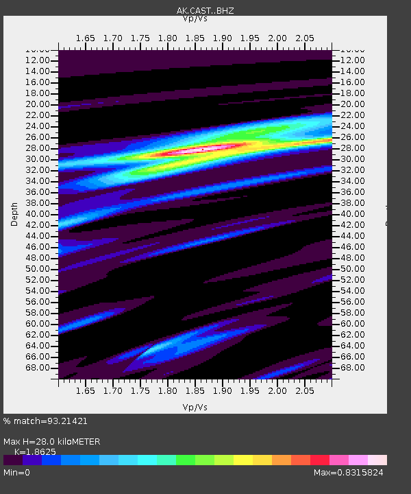
| Estimated Moho Depth: |
28.0 km |
| Estimated Crust Vp/Vs: |
1.86 |
| Assumed Crust Vp: |
6.566 km/s |
| Estimated Crust Vs: |
3.525 km/s |
| Estimated Crust Poisson's Ratio: |
0.30 |
|
| Radial Match: |
93.21421 % |
| Radial Bump: |
400 |
| Transverse Match: |
82.49007 % |
| Transverse Bump: |
400 |
| SOD ConfigId: |
30536071 |
| Insert Time: |
2023-05-24 16:04:33.436 +0000 |
| GWidth: |
2.5 |
| Max Bumps: |
400 |
| Tol: |
0.001 |
|

Signal To Noise
| Channel | StoN | STA | LTA |
| AK:CAST: :BHZ:20230510T16:13:18.828014Z | 47.524876 | 1.1353254E-5 | 2.3889075E-7 |
| AK:CAST: :BHN:20230510T16:13:18.828014Z | 24.236061 | 3.896345E-6 | 1.6076643E-7 |
| AK:CAST: :BHE:20230510T16:13:18.828014Z | 4.6256394 | 1.2569654E-6 | 2.7173877E-7 |
| Arrivals |
| Ps | 3.8 SECOND |
| PpPs | 12 SECOND |
| PsPs/PpSs | 16 SECOND |


