You are here: Home > Network List > AK - Alaska Regional Network Stations List
> Station GLI Glacier Island > Earthquake Result Viewer
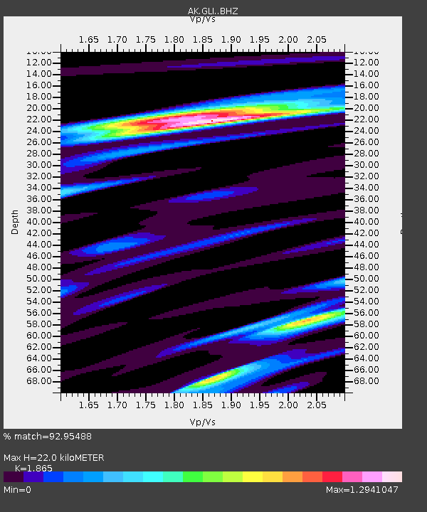
GLI Glacier Island - Earthquake Result Viewer
| Earthquake location: |
Tonga Islands |
| Earthquake latitude/longitude: |
-15.6/-174.6 |
| Earthquake time(UTC): |
2023/05/10 (130) 16:02:00 GMT |
| Earthquake Depth: |
210 km |
| Earthquake Magnitude: |
7.6 mww |
| Earthquake Catalog/Contributor: |
NEIC PDE/us |
|
| Network: |
AK Alaska Regional Network |
| Station: |
GLI Glacier Island |
| Lat/Lon: |
60.88 N/147.09 W |
| Elevation: |
430 m |
|
| Distance: |
79.3 deg |
| Az: |
13.293 deg |
| Baz: |
206.935 deg |
| Ray Param: |
0.0485025 |
| Estimated Moho Depth: |
22.0 km |
| Estimated Crust Vp/Vs: |
1.87 |
| Assumed Crust Vp: |
6.566 km/s |
| Estimated Crust Vs: |
3.521 km/s |
| Estimated Crust Poisson's Ratio: |
0.30 |
|
| Radial Match: |
92.95488 % |
| Radial Bump: |
400 |
| Transverse Match: |
89.08103 % |
| Transverse Bump: |
400 |
| SOD ConfigId: |
30536071 |
| Insert Time: |
2023-05-24 16:05:30.311 +0000 |
| GWidth: |
2.5 |
| Max Bumps: |
400 |
| Tol: |
0.001 |
|

Signal To Noise
| Channel | StoN | STA | LTA |
| AK:GLI: :BHZ:20230510T16:13:11.628002Z | 31.483818 | 1.0836265E-5 | 3.4418522E-7 |
| AK:GLI: :BHN:20230510T16:13:11.628002Z | 13.718864 | 3.8986086E-6 | 2.8417867E-7 |
| AK:GLI: :BHE:20230510T16:13:11.628002Z | 11.3239355 | 4.7068247E-6 | 4.1565272E-7 |
| Arrivals |
| Ps | 3.0 SECOND |
| PpPs | 9.3 SECOND |
| PsPs/PpSs | 12 SECOND |


