You are here: Home > Network List > AK - Alaska Regional Network Stations List
> Station KLU Klutina Pass, Alaska, USA > Earthquake Result Viewer
KLU Klutina Pass, Alaska, USA - Earthquake Result Viewer
| Earthquake location: |
Tonga Islands |
| Earthquake latitude/longitude: |
-15.6/-174.6 |
| Earthquake time(UTC): |
2023/05/10 (130) 16:02:00 GMT |
| Earthquake Depth: |
210 km |
| Earthquake Magnitude: |
7.6 mww |
| Earthquake Catalog/Contributor: |
NEIC PDE/us |
|
| Network: |
AK Alaska Regional Network |
| Station: |
KLU Klutina Pass, Alaska, USA |
| Lat/Lon: |
61.49 N/145.92 W |
| Elevation: |
1021 m |
|
| Distance: |
80.2 deg |
| Az: |
13.517 deg |
| Baz: |
208.001 deg |
| Ray Param: |
0.047953352 |
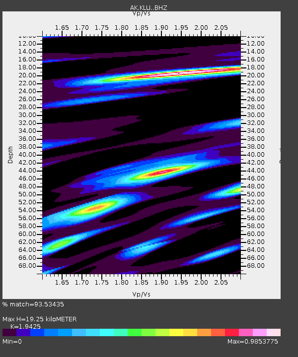
| Estimated Moho Depth: |
19.25 km |
| Estimated Crust Vp/Vs: |
1.94 |
| Assumed Crust Vp: |
6.566 km/s |
| Estimated Crust Vs: |
3.38 km/s |
| Estimated Crust Poisson's Ratio: |
0.32 |
|
| Radial Match: |
93.53435 % |
| Radial Bump: |
400 |
| Transverse Match: |
80.96281 % |
| Transverse Bump: |
400 |
| SOD ConfigId: |
30536071 |
| Insert Time: |
2023-05-24 16:06:10.980 +0000 |
| GWidth: |
2.5 |
| Max Bumps: |
400 |
| Tol: |
0.001 |
|

Signal To Noise
| Channel | StoN | STA | LTA |
| AK:KLU: :BHZ:20230510T16:13:15.948009Z | 20.544565 | 9.197333E-6 | 4.476772E-7 |
| AK:KLU: :BHN:20230510T16:13:15.948009Z | 10.189621 | 3.2911303E-6 | 3.229885E-7 |
| AK:KLU: :BHE:20230510T16:13:15.948009Z | 15.272081 | 2.2424565E-6 | 1.4683371E-7 |
| Arrivals |
| Ps | 2.8 SECOND |
| PpPs | 8.4 SECOND |
| PsPs/PpSs | 11 SECOND |


