You are here: Home > Network List > TA - USArray Transportable Network (new EarthScope stations) Stations List
> Station 333A Richland Springs, TX, USA > Earthquake Result Viewer
333A Richland Springs, TX, USA - Earthquake Result Viewer
| Earthquake location: |
Off Coast Of Central Chile |
| Earthquake latitude/longitude: |
-35.8/-73.2 |
| Earthquake time(UTC): |
2010/03/15 (074) 11:08:28 GMT |
| Earthquake Depth: |
14 km |
| Earthquake Magnitude: |
5.9 MB, 6.1 MS, 6.2 MW, 6.1 MW |
| Earthquake Catalog/Contributor: |
WHDF/NEIC |
|
| Network: |
TA USArray Transportable Network (new EarthScope stations) |
| Station: |
333A Richland Springs, TX, USA |
| Lat/Lon: |
31.32 N/98.98 W |
| Elevation: |
443 m |
|
| Distance: |
71.0 deg |
| Az: |
336.784 deg |
| Baz: |
158.01 deg |
| Ray Param: |
0.05457465 |
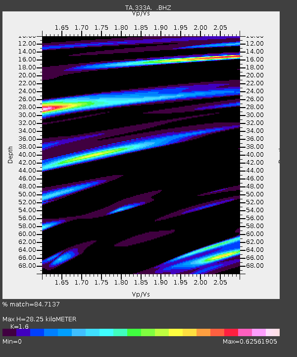
| Estimated Moho Depth: |
28.25 km |
| Estimated Crust Vp/Vs: |
1.60 |
| Assumed Crust Vp: |
6.498 km/s |
| Estimated Crust Vs: |
4.061 km/s |
| Estimated Crust Poisson's Ratio: |
0.18 |
|
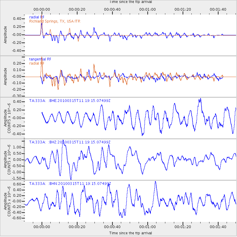
| Radial Match: |
84.7137 % |
| Radial Bump: |
400 |
| Transverse Match: |
61.640892 % |
| Transverse Bump: |
385 |
| SOD ConfigId: |
308276 |
| Insert Time: |
2010-06-22 20:00:23.645 +0000 |
| GWidth: |
2.5 |
| Max Bumps: |
400 |
| Tol: |
0.001 |
|
Signal To Noise
| Channel | StoN | STA | LTA |
| TA:333A: :BHZ:20100315T11:19:15.07499Z | 2.0674725 | 3.7220124E-7 | 1.8002717E-7 |
| TA:333A: :BHN:20100315T11:19:15.07499Z | 1.9713072 | 2.0189412E-7 | 1.02416365E-7 |
| TA:333A: :BHE:20100315T11:19:15.07499Z | 1.7417877 | 1.7637701E-7 | 1.0126206E-7 |
| Arrivals |
| Ps | 2.7 SECOND |
| PpPs | 11 SECOND |
| PsPs/PpSs | 14 SECOND |


