You are here: Home > Network List > AK - Alaska Regional Network Stations List
> Station PAX Paxson > Earthquake Result Viewer
PAX Paxson - Earthquake Result Viewer
| Earthquake location: |
Tonga Islands |
| Earthquake latitude/longitude: |
-15.6/-174.6 |
| Earthquake time(UTC): |
2023/05/10 (130) 16:02:00 GMT |
| Earthquake Depth: |
210 km |
| Earthquake Magnitude: |
7.6 mww |
| Earthquake Catalog/Contributor: |
NEIC PDE/us |
|
| Network: |
AK Alaska Regional Network |
| Station: |
PAX Paxson |
| Lat/Lon: |
62.97 N/145.47 W |
| Elevation: |
1130 m |
|
| Distance: |
81.6 deg |
| Az: |
12.998 deg |
| Baz: |
208.319 deg |
| Ray Param: |
0.046983078 |
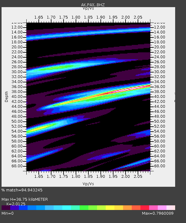
| Estimated Moho Depth: |
36.75 km |
| Estimated Crust Vp/Vs: |
2.01 |
| Assumed Crust Vp: |
6.566 km/s |
| Estimated Crust Vs: |
3.263 km/s |
| Estimated Crust Poisson's Ratio: |
0.34 |
|
| Radial Match: |
94.943245 % |
| Radial Bump: |
400 |
| Transverse Match: |
83.031525 % |
| Transverse Bump: |
400 |
| SOD ConfigId: |
30536071 |
| Insert Time: |
2023-05-24 16:06:57.109 +0000 |
| GWidth: |
2.5 |
| Max Bumps: |
400 |
| Tol: |
0.001 |
|

Signal To Noise
| Channel | StoN | STA | LTA |
| AK:PAX: :BHZ:20230510T16:13:23.367992Z | 59.24872 | 8.243456E-6 | 1.3913308E-7 |
| AK:PAX: :BHN:20230510T16:13:23.367992Z | 16.446533 | 2.5743352E-6 | 1.5652753E-7 |
| AK:PAX: :BHE:20230510T16:13:23.367992Z | 6.8954973 | 1.5088926E-6 | 2.1882289E-7 |
| Arrivals |
| Ps | 5.8 SECOND |
| PpPs | 16 SECOND |
| PsPs/PpSs | 22 SECOND |


