You are here: Home > Network List > AK - Alaska Regional Network Stations List
> Station PS06 TAPS Pump Station 6, AK, USA > Earthquake Result Viewer
PS06 TAPS Pump Station 6, AK, USA - Earthquake Result Viewer
| Earthquake location: |
Tonga Islands |
| Earthquake latitude/longitude: |
-15.6/-174.6 |
| Earthquake time(UTC): |
2023/05/10 (130) 16:02:00 GMT |
| Earthquake Depth: |
210 km |
| Earthquake Magnitude: |
7.6 mww |
| Earthquake Catalog/Contributor: |
NEIC PDE/us |
|
| Network: |
AK Alaska Regional Network |
| Station: |
PS06 TAPS Pump Station 6, AK, USA |
| Lat/Lon: |
65.85 N/149.74 W |
| Elevation: |
280 m |
|
| Distance: |
83.3 deg |
| Az: |
10.031 deg |
| Baz: |
204.081 deg |
| Ray Param: |
0.045748163 |
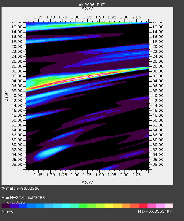
| Estimated Moho Depth: |
32.0 km |
| Estimated Crust Vp/Vs: |
1.85 |
| Assumed Crust Vp: |
6.566 km/s |
| Estimated Crust Vs: |
3.544 km/s |
| Estimated Crust Poisson's Ratio: |
0.29 |
|
| Radial Match: |
96.62266 % |
| Radial Bump: |
400 |
| Transverse Match: |
91.43515 % |
| Transverse Bump: |
400 |
| SOD ConfigId: |
30536071 |
| Insert Time: |
2023-05-24 16:07:04.668 +0000 |
| GWidth: |
2.5 |
| Max Bumps: |
400 |
| Tol: |
0.001 |
|

Signal To Noise
| Channel | StoN | STA | LTA |
| AK:PS06: :BHZ:20230510T16:13:32.528026Z | 61.81448 | 7.703165E-6 | 1.2461747E-7 |
| AK:PS06: :BHN:20230510T16:13:32.528026Z | 22.279936 | 2.3398661E-6 | 1.0502123E-7 |
| AK:PS06: :BHE:20230510T16:13:32.528026Z | 19.34011 | 1.3176892E-6 | 6.813245E-8 |
| Arrivals |
| Ps | 4.3 SECOND |
| PpPs | 14 SECOND |
| PsPs/PpSs | 18 SECOND |


