You are here: Home > Network List > TA - USArray Transportable Network (new EarthScope stations) Stations List
> Station 336A Riesel, TX, USA > Earthquake Result Viewer
336A Riesel, TX, USA - Earthquake Result Viewer

| Earthquake location: |
Off Coast Of Central Chile |
| Earthquake latitude/longitude: |
-35.8/-73.2 |
| Earthquake time(UTC): |
2010/03/15 (074) 11:08:28 GMT |
| Earthquake Depth: |
14 km |
| Earthquake Magnitude: |
5.9 MB, 6.1 MS, 6.2 MW, 6.1 MW |
| Earthquake Catalog/Contributor: |
WHDF/NEIC |
|
| Network: |
TA USArray Transportable Network (new EarthScope stations) |
| Station: |
336A Riesel, TX, USA |
| Lat/Lon: |
31.39 N/96.84 W |
| Elevation: |
140 m |
|
| Distance: |
70.4 deg |
| Az: |
338.617 deg |
| Baz: |
159.723 deg |
| Ray Param: |
0.054973986 |
| Estimated Moho Depth: |
31.25 km |
| Estimated Crust Vp/Vs: |
1.76 |
| Assumed Crust Vp: |
6.347 km/s |
| Estimated Crust Vs: |
3.606 km/s |
| Estimated Crust Poisson's Ratio: |
0.26 |
|
| Radial Match: |
81.35328 % |
| Radial Bump: |
280 |
| Transverse Match: |
73.16757 % |
| Transverse Bump: |
399 |
| SOD ConfigId: |
308276 |
| Insert Time: |
2010-06-22 20:01:02.025 +0000 |
| GWidth: |
2.5 |
| Max Bumps: |
400 |
| Tol: |
0.001 |
|
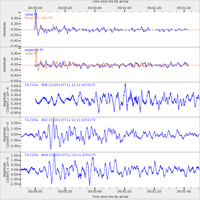
Signal To Noise
| Channel | StoN | STA | LTA |
| TA:336A: :BHZ:20100315T11:19:11.425027Z | 2.7563932 | 4.84897E-7 | 1.759172E-7 |
| TA:336A: :BHN:20100315T11:19:11.425027Z | 1.3543814 | 2.2521435E-7 | 1.6628577E-7 |
| TA:336A: :BHE:20100315T11:19:11.425027Z | 1.5040188 | 2.5129864E-7 | 1.6708479E-7 |
| Arrivals |
| Ps | 3.9 SECOND |
| PpPs | 13 SECOND |
| PsPs/PpSs | 17 SECOND |


