You are here: Home > Network List > AK - Alaska Regional Network Stations List
> Station WAT7 Susitna Watana 7, AK, USA > Earthquake Result Viewer
WAT7 Susitna Watana 7, AK, USA - Earthquake Result Viewer
| Earthquake location: |
Tonga Islands |
| Earthquake latitude/longitude: |
-15.6/-174.6 |
| Earthquake time(UTC): |
2023/05/10 (130) 16:02:00 GMT |
| Earthquake Depth: |
210 km |
| Earthquake Magnitude: |
7.6 mww |
| Earthquake Catalog/Contributor: |
NEIC PDE/us |
|
| Network: |
AK Alaska Regional Network |
| Station: |
WAT7 Susitna Watana 7, AK, USA |
| Lat/Lon: |
62.83 N/148.85 W |
| Elevation: |
1232 m |
|
| Distance: |
80.7 deg |
| Az: |
11.661 deg |
| Baz: |
205.108 deg |
| Ray Param: |
0.047552302 |
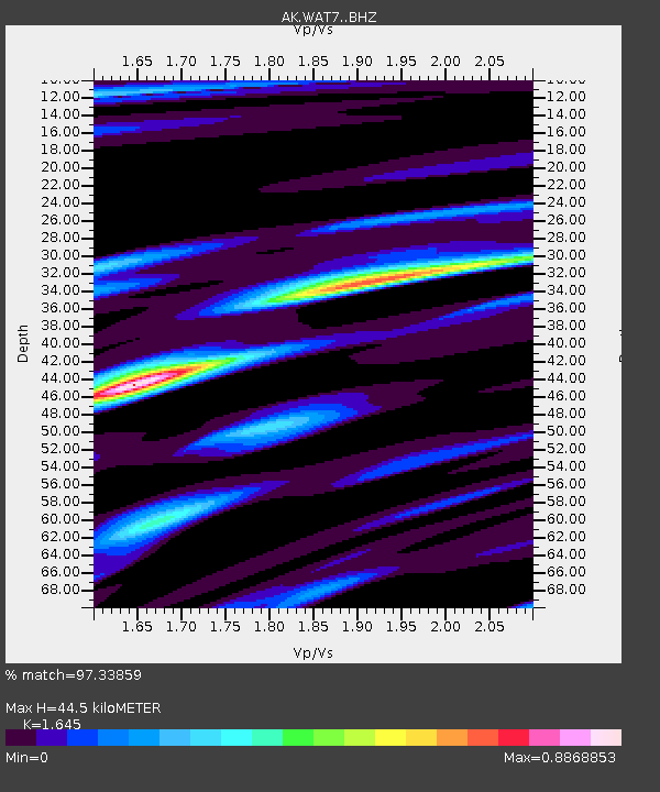
| Estimated Moho Depth: |
44.5 km |
| Estimated Crust Vp/Vs: |
1.64 |
| Assumed Crust Vp: |
6.566 km/s |
| Estimated Crust Vs: |
3.992 km/s |
| Estimated Crust Poisson's Ratio: |
0.21 |
|
| Radial Match: |
97.33859 % |
| Radial Bump: |
400 |
| Transverse Match: |
93.38979 % |
| Transverse Bump: |
400 |
| SOD ConfigId: |
30536071 |
| Insert Time: |
2023-05-24 16:07:57.707 +0000 |
| GWidth: |
2.5 |
| Max Bumps: |
400 |
| Tol: |
0.001 |
|

Signal To Noise
| Channel | StoN | STA | LTA |
| AK:WAT7: :BHZ:20230510T16:13:19.076Z | 63.152225 | 1.1582955E-5 | 1.8341326E-7 |
| AK:WAT7: :BHN:20230510T16:13:19.076Z | 15.298666 | 3.6048223E-6 | 2.3562983E-7 |
| AK:WAT7: :BHE:20230510T16:13:19.076Z | 12.572018 | 1.992521E-6 | 1.5848856E-7 |
| Arrivals |
| Ps | 4.5 SECOND |
| PpPs | 17 SECOND |
| PsPs/PpSs | 22 SECOND |


