You are here: Home > Network List > AV - Alaska Volcano Observatory Stations List
> Station GAKI Kavalga Island, Gareloi Volcano, Alaska > Earthquake Result Viewer
GAKI Kavalga Island, Gareloi Volcano, Alaska - Earthquake Result Viewer
| Earthquake location: |
Tonga Islands |
| Earthquake latitude/longitude: |
-15.6/-174.6 |
| Earthquake time(UTC): |
2023/05/10 (130) 16:02:00 GMT |
| Earthquake Depth: |
210 km |
| Earthquake Magnitude: |
7.6 mww |
| Earthquake Catalog/Contributor: |
NEIC PDE/us |
|
| Network: |
AV Alaska Volcano Observatory |
| Station: |
GAKI Kavalga Island, Gareloi Volcano, Alaska |
| Lat/Lon: |
51.55 N/178.81 W |
| Elevation: |
99 m |
|
| Distance: |
67.0 deg |
| Az: |
357.148 deg |
| Baz: |
175.595 deg |
| Ray Param: |
0.05665853 |
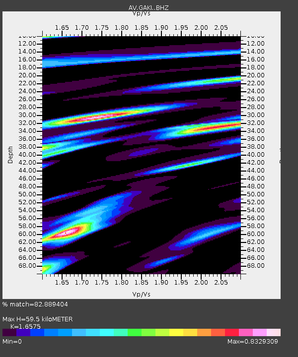
| Estimated Moho Depth: |
59.5 km |
| Estimated Crust Vp/Vs: |
1.66 |
| Assumed Crust Vp: |
6.048 km/s |
| Estimated Crust Vs: |
3.649 km/s |
| Estimated Crust Poisson's Ratio: |
0.21 |
|
| Radial Match: |
82.889404 % |
| Radial Bump: |
400 |
| Transverse Match: |
72.507744 % |
| Transverse Bump: |
400 |
| SOD ConfigId: |
30536071 |
| Insert Time: |
2023-05-24 16:10:33.814 +0000 |
| GWidth: |
2.5 |
| Max Bumps: |
400 |
| Tol: |
0.001 |
|

Signal To Noise
| Channel | StoN | STA | LTA |
| AV:GAKI: :BHZ:20230510T16:11:59.479992Z | 6.814816 | 1.0897033E-5 | 1.5990207E-6 |
| AV:GAKI: :BHN:20230510T16:11:59.479992Z | 2.1966052 | 5.179185E-6 | 2.3578132E-6 |
| AV:GAKI: :BHE:20230510T16:11:59.479992Z | 0.98967904 | 2.1913895E-6 | 2.2142426E-6 |
| Arrivals |
| Ps | 6.7 SECOND |
| PpPs | 25 SECOND |
| PsPs/PpSs | 32 SECOND |


