You are here: Home > Network List > AV - Alaska Volcano Observatory Stations List
> Station KAVE Katnai Ventifact, Alaska > Earthquake Result Viewer
KAVE Katnai Ventifact, Alaska - Earthquake Result Viewer
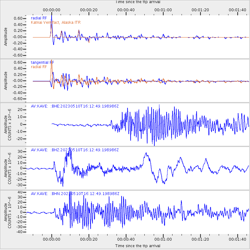
| Earthquake location: |
Tonga Islands |
| Earthquake latitude/longitude: |
-15.6/-174.6 |
| Earthquake time(UTC): |
2023/05/10 (130) 16:02:00 GMT |
| Earthquake Depth: |
210 km |
| Earthquake Magnitude: |
7.6 mww |
| Earthquake Catalog/Contributor: |
NEIC PDE/us |
|
| Network: |
AV Alaska Volcano Observatory |
| Station: |
KAVE Katnai Ventifact, Alaska |
| Lat/Lon: |
58.20 N/155.02 W |
| Elevation: |
702 m |
|
| Distance: |
75.3 deg |
| Az: |
10.575 deg |
| Baz: |
199.509 deg |
| Ray Param: |
0.051217027 |
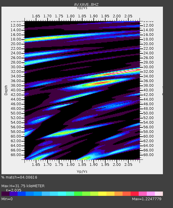
| Estimated Moho Depth: |
31.75 km |
| Estimated Crust Vp/Vs: |
2.04 |
| Assumed Crust Vp: |
6.438 km/s |
| Estimated Crust Vs: |
3.164 km/s |
| Estimated Crust Poisson's Ratio: |
0.34 |
|
| Radial Match: |
84.08616 % |
| Radial Bump: |
400 |
| Transverse Match: |
66.52005 % |
| Transverse Bump: |
400 |
| SOD ConfigId: |
30536071 |
| Insert Time: |
2023-05-24 16:11:08.272 +0000 |
| GWidth: |
2.5 |
| Max Bumps: |
400 |
| Tol: |
0.001 |
|
Signal To Noise
| Channel | StoN | STA | LTA |
| AV:KAVE: :BHZ:20230510T16:12:49.198986Z | 16.135365 | 1.1450334E-5 | 7.096421E-7 |
| AV:KAVE: :BHN:20230510T16:12:49.198986Z | 8.128204 | 6.154612E-6 | 7.571921E-7 |
| AV:KAVE: :BHE:20230510T16:12:49.198986Z | 3.5985491 | 3.0826523E-6 | 8.566375E-7 |
| Arrivals |
| Ps | 5.2 SECOND |
| PpPs | 15 SECOND |
| PsPs/PpSs | 20 SECOND |


