You are here: Home > Network List > AV - Alaska Volcano Observatory Stations List
> Station KIMD MID Benchmark, Kanaga Volcano, Alaska > Earthquake Result Viewer
KIMD MID Benchmark, Kanaga Volcano, Alaska - Earthquake Result Viewer
| Earthquake location: |
Tonga Islands |
| Earthquake latitude/longitude: |
-15.6/-174.6 |
| Earthquake time(UTC): |
2023/05/10 (130) 16:02:00 GMT |
| Earthquake Depth: |
210 km |
| Earthquake Magnitude: |
7.6 mww |
| Earthquake Catalog/Contributor: |
NEIC PDE/us |
|
| Network: |
AV Alaska Volcano Observatory |
| Station: |
KIMD MID Benchmark, Kanaga Volcano, Alaska |
| Lat/Lon: |
51.76 N/177.24 W |
| Elevation: |
183 m |
|
| Distance: |
67.1 deg |
| Az: |
358.227 deg |
| Baz: |
177.25 deg |
| Ray Param: |
0.056560576 |
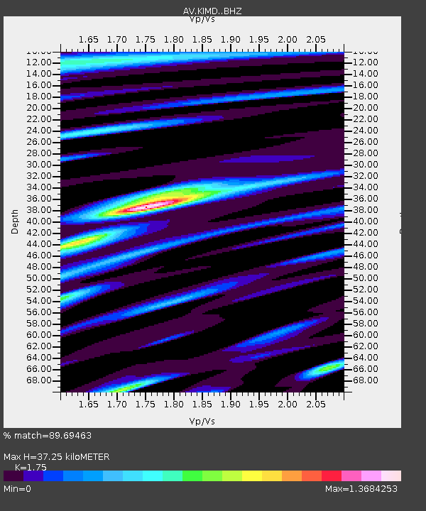
| Estimated Moho Depth: |
37.25 km |
| Estimated Crust Vp/Vs: |
1.75 |
| Assumed Crust Vp: |
5.88 km/s |
| Estimated Crust Vs: |
3.36 km/s |
| Estimated Crust Poisson's Ratio: |
0.26 |
|
| Radial Match: |
89.69463 % |
| Radial Bump: |
400 |
| Transverse Match: |
76.70616 % |
| Transverse Bump: |
400 |
| SOD ConfigId: |
30536071 |
| Insert Time: |
2023-05-24 16:11:15.176 +0000 |
| GWidth: |
2.5 |
| Max Bumps: |
400 |
| Tol: |
0.001 |
|

Signal To Noise
| Channel | StoN | STA | LTA |
| AV:KIMD: :BHZ:20230510T16:12:00.399975Z | 9.703599 | 1.133154E-5 | 1.1677668E-6 |
| AV:KIMD: :BHN:20230510T16:12:00.399975Z | 2.7841692 | 4.8231127E-6 | 1.7323346E-6 |
| AV:KIMD: :BHE:20230510T16:12:00.399975Z | 0.9815358 | 1.6081175E-6 | 1.6383688E-6 |
| Arrivals |
| Ps | 4.9 SECOND |
| PpPs | 17 SECOND |
| PsPs/PpSs | 22 SECOND |


