You are here: Home > Network List > AV - Alaska Volcano Observatory Stations List
> Station MNAT Nateekin Bay, Makushin Volcano, Alaska > Earthquake Result Viewer
MNAT Nateekin Bay, Makushin Volcano, Alaska - Earthquake Result Viewer

| Earthquake location: |
Tonga Islands |
| Earthquake latitude/longitude: |
-15.6/-174.6 |
| Earthquake time(UTC): |
2023/05/10 (130) 16:02:00 GMT |
| Earthquake Depth: |
210 km |
| Earthquake Magnitude: |
7.6 mww |
| Earthquake Catalog/Contributor: |
NEIC PDE/us |
|
| Network: |
AV Alaska Volcano Observatory |
| Station: |
MNAT Nateekin Bay, Makushin Volcano, Alaska |
| Lat/Lon: |
53.88 N/166.69 W |
| Elevation: |
390 m |
|
| Distance: |
69.5 deg |
| Az: |
4.996 deg |
| Baz: |
188.15 deg |
| Ray Param: |
0.055000138 |
| Estimated Moho Depth: |
41.25 km |
| Estimated Crust Vp/Vs: |
1.60 |
| Assumed Crust Vp: |
3.943 km/s |
| Estimated Crust Vs: |
2.465 km/s |
| Estimated Crust Poisson's Ratio: |
0.18 |
|
| Radial Match: |
91.47519 % |
| Radial Bump: |
400 |
| Transverse Match: |
82.937546 % |
| Transverse Bump: |
400 |
| SOD ConfigId: |
30536071 |
| Insert Time: |
2023-05-24 16:11:46.472 +0000 |
| GWidth: |
2.5 |
| Max Bumps: |
400 |
| Tol: |
0.001 |
|
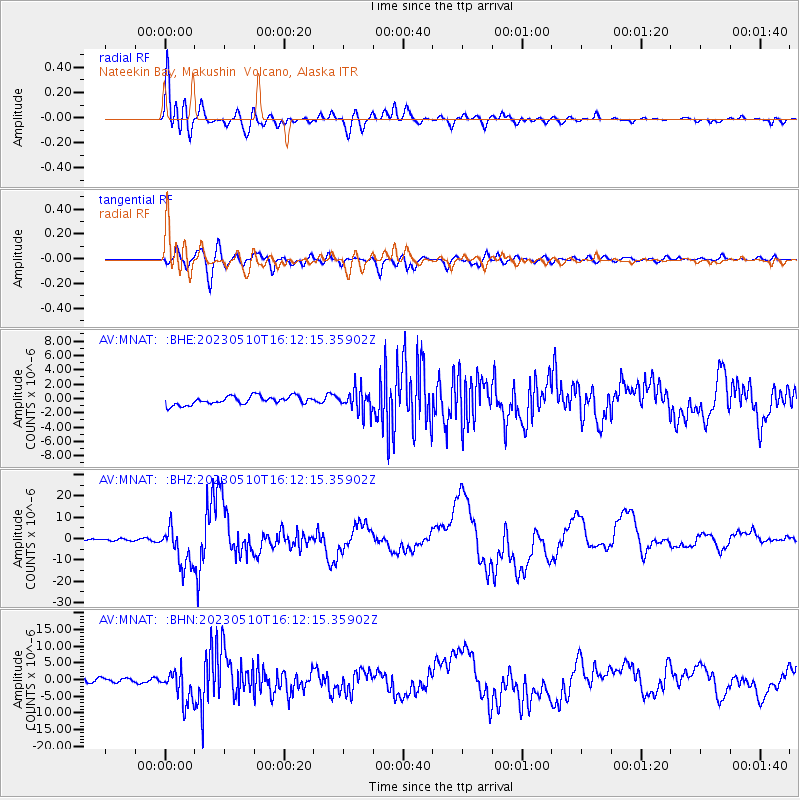
Signal To Noise
| Channel | StoN | STA | LTA |
| AV:MNAT: :BHZ:20230510T16:12:15.35902Z | 27.270517 | 9.4834795E-6 | 3.4775576E-7 |
| AV:MNAT: :BHN:20230510T16:12:15.35902Z | 5.1074758 | 4.917841E-6 | 9.628711E-7 |
| AV:MNAT: :BHE:20230510T16:12:15.35902Z | 2.6960232 | 1.5733247E-6 | 5.8357233E-7 |
| Arrivals |
| Ps | 6.4 SECOND |
| PpPs | 27 SECOND |
| PsPs/PpSs | 33 SECOND |


