You are here: Home > Network List > AV - Alaska Volcano Observatory Stations List
> Station PLBL Mt. Peulik Volcano, Alaska > Earthquake Result Viewer
PLBL Mt. Peulik Volcano, Alaska - Earthquake Result Viewer
| Earthquake location: |
Tonga Islands |
| Earthquake latitude/longitude: |
-15.6/-174.6 |
| Earthquake time(UTC): |
2023/05/10 (130) 16:02:00 GMT |
| Earthquake Depth: |
210 km |
| Earthquake Magnitude: |
7.6 mww |
| Earthquake Catalog/Contributor: |
NEIC PDE/us |
|
| Network: |
AV Alaska Volcano Observatory |
| Station: |
PLBL Mt. Peulik Volcano, Alaska |
| Lat/Lon: |
57.70 N/156.82 W |
| Elevation: |
461 m |
|
| Distance: |
74.5 deg |
| Az: |
9.8 deg |
| Baz: |
197.786 deg |
| Ray Param: |
0.051740095 |
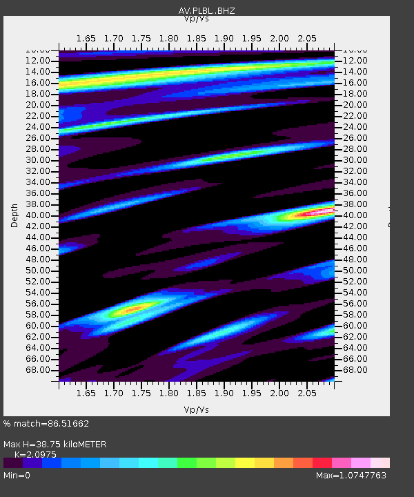
| Estimated Moho Depth: |
38.75 km |
| Estimated Crust Vp/Vs: |
2.10 |
| Assumed Crust Vp: |
6.1 km/s |
| Estimated Crust Vs: |
2.908 km/s |
| Estimated Crust Poisson's Ratio: |
0.35 |
|
| Radial Match: |
86.51662 % |
| Radial Bump: |
400 |
| Transverse Match: |
75.7336 % |
| Transverse Bump: |
400 |
| SOD ConfigId: |
30536071 |
| Insert Time: |
2023-05-24 16:12:06.958 +0000 |
| GWidth: |
2.5 |
| Max Bumps: |
400 |
| Tol: |
0.001 |
|
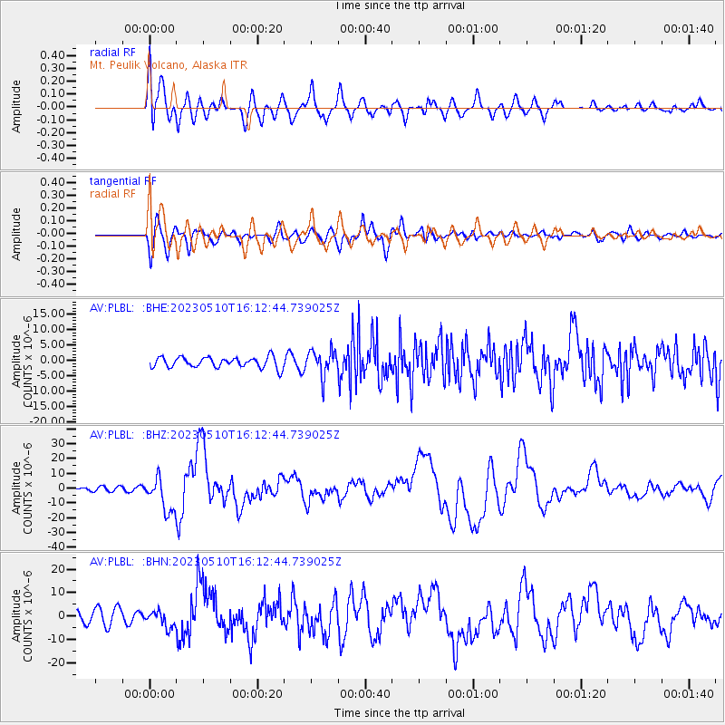
Signal To Noise
| Channel | StoN | STA | LTA |
| AV:PLBL: :BHZ:20230510T16:12:44.739025Z | 7.870718 | 1.2144611E-5 | 1.5430119E-6 |
| AV:PLBL: :BHN:20230510T16:12:44.739025Z | 1.3376199 | 3.5213939E-6 | 2.632582E-6 |
| AV:PLBL: :BHE:20230510T16:12:44.739025Z | 2.5280862 | 4.317431E-6 | 1.7077863E-6 |
| Arrivals |
| Ps | 7.1 SECOND |
| PpPs | 19 SECOND |
| PsPs/PpSs | 26 SECOND |


