You are here: Home > Network List > AV - Alaska Volcano Observatory Stations List
> Station SSLS South, Shishaldin Volcano, Alaska > Earthquake Result Viewer
SSLS South, Shishaldin Volcano, Alaska - Earthquake Result Viewer
| Earthquake location: |
Tonga Islands |
| Earthquake latitude/longitude: |
-15.6/-174.6 |
| Earthquake time(UTC): |
2023/05/10 (130) 16:02:00 GMT |
| Earthquake Depth: |
210 km |
| Earthquake Magnitude: |
7.6 mww |
| Earthquake Catalog/Contributor: |
NEIC PDE/us |
|
| Network: |
AV Alaska Volcano Observatory |
| Station: |
SSLS South, Shishaldin Volcano, Alaska |
| Lat/Lon: |
54.71 N/164.00 W |
| Elevation: |
817 m |
|
| Distance: |
70.6 deg |
| Az: |
6.502 deg |
| Baz: |
190.838 deg |
| Ray Param: |
0.054296445 |
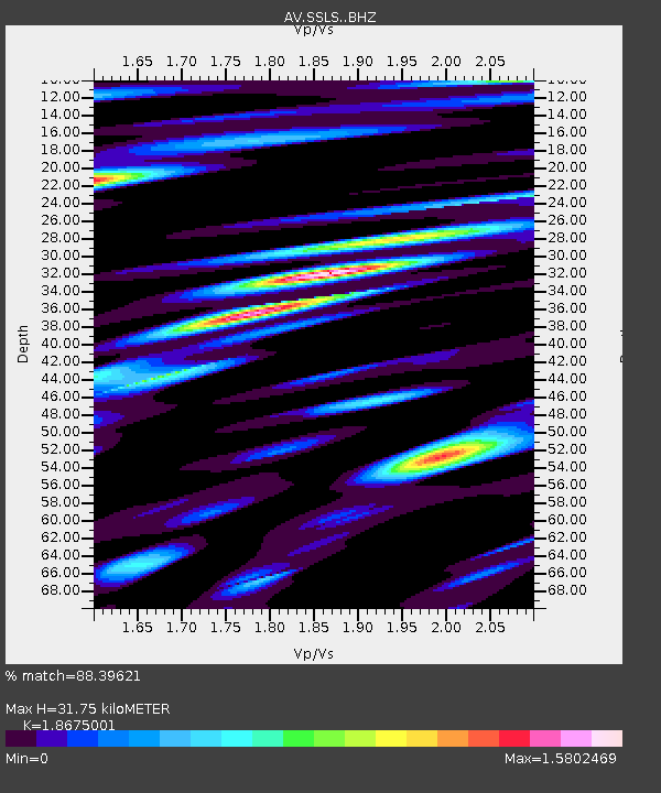
| Estimated Moho Depth: |
31.75 km |
| Estimated Crust Vp/Vs: |
1.87 |
| Assumed Crust Vp: |
5.989 km/s |
| Estimated Crust Vs: |
3.207 km/s |
| Estimated Crust Poisson's Ratio: |
0.30 |
|
| Radial Match: |
88.39621 % |
| Radial Bump: |
400 |
| Transverse Match: |
83.846176 % |
| Transverse Bump: |
400 |
| SOD ConfigId: |
30536071 |
| Insert Time: |
2023-05-24 16:12:45.310 +0000 |
| GWidth: |
2.5 |
| Max Bumps: |
400 |
| Tol: |
0.001 |
|

Signal To Noise
| Channel | StoN | STA | LTA |
| AV:SSLS: :BHZ:20230510T16:12:21.880016Z | 21.617146 | 1.5430556E-5 | 7.13811E-7 |
| AV:SSLS: :BHN:20230510T16:12:21.880016Z | 7.7536664 | 8.632077E-6 | 1.1132897E-6 |
| AV:SSLS: :BHE:20230510T16:12:21.880016Z | 3.8648872 | 5.7161483E-6 | 1.4789948E-6 |
| Arrivals |
| Ps | 4.7 SECOND |
| PpPs | 15 SECOND |
| PsPs/PpSs | 19 SECOND |


