You are here: Home > Network List > AV - Alaska Volcano Observatory Stations List
> Station TAFL Flats, Tanaga Volcano, Alaska > Earthquake Result Viewer
TAFL Flats, Tanaga Volcano, Alaska - Earthquake Result Viewer
| Earthquake location: |
Tonga Islands |
| Earthquake latitude/longitude: |
-15.6/-174.6 |
| Earthquake time(UTC): |
2023/05/10 (130) 16:02:00 GMT |
| Earthquake Depth: |
210 km |
| Earthquake Magnitude: |
7.6 mww |
| Earthquake Catalog/Contributor: |
NEIC PDE/us |
|
| Network: |
AV Alaska Volcano Observatory |
| Station: |
TAFL Flats, Tanaga Volcano, Alaska |
| Lat/Lon: |
51.76 N/177.90 W |
| Elevation: |
186 m |
|
| Distance: |
67.1 deg |
| Az: |
357.78 deg |
| Baz: |
176.557 deg |
| Ray Param: |
0.056548957 |
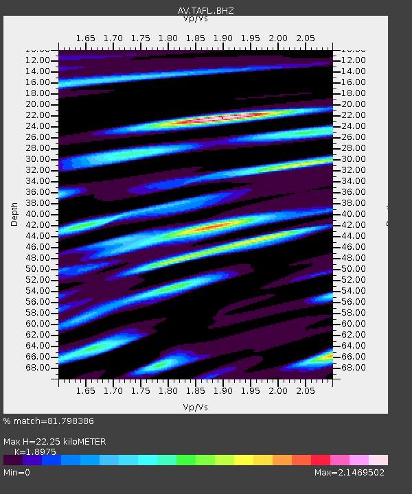
| Estimated Moho Depth: |
22.25 km |
| Estimated Crust Vp/Vs: |
1.90 |
| Assumed Crust Vp: |
5.88 km/s |
| Estimated Crust Vs: |
3.099 km/s |
| Estimated Crust Poisson's Ratio: |
0.31 |
|
| Radial Match: |
81.798386 % |
| Radial Bump: |
400 |
| Transverse Match: |
66.52502 % |
| Transverse Bump: |
400 |
| SOD ConfigId: |
30536071 |
| Insert Time: |
2023-05-24 16:12:48.316 +0000 |
| GWidth: |
2.5 |
| Max Bumps: |
400 |
| Tol: |
0.001 |
|

Signal To Noise
| Channel | StoN | STA | LTA |
| AV:TAFL: :BHZ:20230510T16:12:00.518993Z | 6.365512 | 1.339419E-5 | 2.1041812E-6 |
| AV:TAFL: :BHN:20230510T16:12:00.518993Z | 1.8531635 | 7.648572E-6 | 4.127305E-6 |
| AV:TAFL: :BHE:20230510T16:12:00.518993Z | 0.7144792 | 2.9085188E-6 | 4.0708237E-6 |
| Arrivals |
| Ps | 3.5 SECOND |
| PpPs | 11 SECOND |
| PsPs/PpSs | 14 SECOND |


