You are here: Home > Network List > AV - Alaska Volcano Observatory Stations List
> Station VNKR Kametolook River, Mount Veniaminof, Alaska > Earthquake Result Viewer
VNKR Kametolook River, Mount Veniaminof, Alaska - Earthquake Result Viewer
| Earthquake location: |
Tonga Islands |
| Earthquake latitude/longitude: |
-15.6/-174.6 |
| Earthquake time(UTC): |
2023/05/10 (130) 16:02:00 GMT |
| Earthquake Depth: |
210 km |
| Earthquake Magnitude: |
7.6 mww |
| Earthquake Catalog/Contributor: |
NEIC PDE/us |
|
| Network: |
AV Alaska Volcano Observatory |
| Station: |
VNKR Kametolook River, Mount Veniaminof, Alaska |
| Lat/Lon: |
56.03 N/159.37 W |
| Elevation: |
620 m |
|
| Distance: |
72.5 deg |
| Az: |
8.899 deg |
| Baz: |
195.4 deg |
| Ray Param: |
0.053056464 |
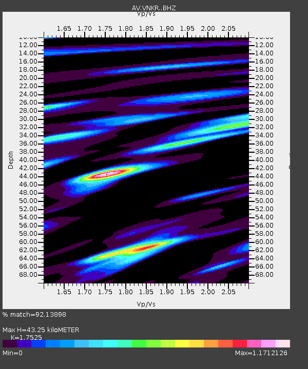
| Estimated Moho Depth: |
43.25 km |
| Estimated Crust Vp/Vs: |
1.75 |
| Assumed Crust Vp: |
6.134 km/s |
| Estimated Crust Vs: |
3.5 km/s |
| Estimated Crust Poisson's Ratio: |
0.26 |
|
| Radial Match: |
92.13898 % |
| Radial Bump: |
400 |
| Transverse Match: |
81.9373 % |
| Transverse Bump: |
400 |
| SOD ConfigId: |
30536071 |
| Insert Time: |
2023-05-24 16:12:59.145 +0000 |
| GWidth: |
2.5 |
| Max Bumps: |
400 |
| Tol: |
0.001 |
|

Signal To Noise
| Channel | StoN | STA | LTA |
| AV:VNKR: :BHZ:20230510T16:12:33.11903Z | 16.139519 | 1.233923E-5 | 7.6453523E-7 |
| AV:VNKR: :BHN:20230510T16:12:33.11903Z | 6.3752985 | 5.60242E-6 | 8.7876987E-7 |
| AV:VNKR: :BHE:20230510T16:12:33.11903Z | 4.2175035 | 4.041832E-6 | 9.583471E-7 |
| Arrivals |
| Ps | 5.5 SECOND |
| PpPs | 19 SECOND |
| PsPs/PpSs | 24 SECOND |


