You are here: Home > Network List > BC - Red Sismica del Noroeste de Mexico Stations List
> Station PIX Pinacate, , SON, MEXICO > Earthquake Result Viewer
PIX Pinacate, , SON, MEXICO - Earthquake Result Viewer
| Earthquake location: |
Tonga Islands |
| Earthquake latitude/longitude: |
-15.6/-174.6 |
| Earthquake time(UTC): |
2023/05/10 (130) 16:02:00 GMT |
| Earthquake Depth: |
210 km |
| Earthquake Magnitude: |
7.6 mww |
| Earthquake Catalog/Contributor: |
NEIC PDE/us |
|
| Network: |
BC Red Sismica del Noroeste de Mexico |
| Station: |
PIX Pinacate, , SON, MEXICO |
| Lat/Lon: |
31.56 N/113.46 W |
| Elevation: |
78 m |
|
| Distance: |
75.1 deg |
| Az: |
50.697 deg |
| Baz: |
240.87 deg |
| Ray Param: |
0.051365945 |
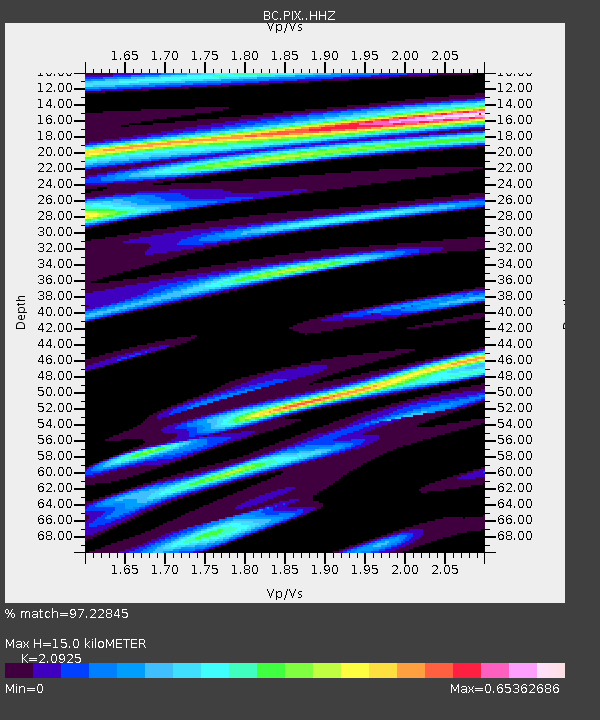
| Estimated Moho Depth: |
15.0 km |
| Estimated Crust Vp/Vs: |
2.09 |
| Assumed Crust Vp: |
6.276 km/s |
| Estimated Crust Vs: |
2.999 km/s |
| Estimated Crust Poisson's Ratio: |
0.35 |
|
| Radial Match: |
97.22845 % |
| Radial Bump: |
326 |
| Transverse Match: |
88.91413 % |
| Transverse Bump: |
400 |
| SOD ConfigId: |
30536071 |
| Insert Time: |
2023-05-24 16:13:46.654 +0000 |
| GWidth: |
2.5 |
| Max Bumps: |
400 |
| Tol: |
0.001 |
|

Signal To Noise
| Channel | StoN | STA | LTA |
| BC:PIX: :HHZ:20230510T16:12:47.950023Z | 22.525845 | 3.852356E-6 | 1.7101937E-7 |
| BC:PIX: :HHN:20230510T16:12:47.950023Z | 1.491695 | 4.155094E-7 | 2.7854847E-7 |
| BC:PIX: :HHE:20230510T16:12:47.950023Z | 4.4092994 | 1.1734404E-6 | 2.6612852E-7 |
| Arrivals |
| Ps | 2.7 SECOND |
| PpPs | 7.2 SECOND |
| PsPs/PpSs | 9.9 SECOND |


